Adam's Bridge Marine National Park
| Adam's Bridge Marine National Park | ||
|---|---|---|
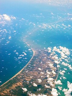
| Adams Bridge with Mannar Island in the foreground. | ||
|
|
||
| Location: | Sri Lanka | |
| Next city: | Mannar | |
| Surface: | 189.9 km² | |
| Founding: | June 22, 2015 | |
The Adams Bridge Marine National Park is a national park around the Adams Bridge in northern Sri Lanka , about 30 km northwest of Mannar .
history
An integrated strategic environmental assessment of the Northern Province prepared by the government with the support of the United Nations Development Program and the United Nations Environment Program and published in October 2014 recommended the establishment of a national park with an area of 18,990 hectares on the Sri Lankan section of Adam's Bridge. In May 2015, the government announced that part of the Adams Bridge would be declared national parks along with Chundikkulam National Park , Delft National Park and Madhu Road National Park. The Adams Bridge became a national park on June 22, 2015 with an area of 189.9 km². The Indian part of the Adam's Bridge is part of the Gulf of Mannar Marine National Park .
Flora and fauna
Many migratory birds follow the Pamban- Adam's Bridge- Mannar route when flying to / from Sri Lanka. The sand dunes of the Adam's Bridge are also used as breeding grounds by birds such as the brown noddi . Numerous species of fish and seaweed thrive in the shallow waters of Adam's Bridge. The marine life around Adam's Bridge includes dolphins , dugongs, and turtles .
Individual evidence
- ^ Integrated Strategic Environmental Assessment of the Northern Province of Sri Lanka
- ↑ a b Will conservation boom in the north?
- ↑ a b Wild north gets Govt's helping hand at last
- ^ Department of Wildlife Conservation - National Parks

