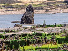
Menhir of Menozac'h
The menhir of Menozac'h (also called Menhir de Saint Cava or Men Ozarc'h) stands east of the lighthouse of the Île Wrac'h , on Plage de Saint-Cava, in Plouguerneau in the Finistère department on the north coast of Brittany in France . The menhir covered with algae is about 1.7 m high and measures 80 × 50 cm at the base.
Sea level rise
Some megaliths like the Allée couverte in the Estuaire de la Quillimadec , like the Menhir of Menozac'h, are completely flooded today at high tide . They are evidence of the rise in sea levels since the Neolithic Age , when the systems were not built so close to the sea but on solid ground. Other examples are the Allée couverte by Kernic , the Cairn de Îlot-de-Roc'h-Avel, the menhir by Léhan and the menhir by Penloïc.
See also
literature
- Pierre-Roland Giot: Prehistory in Brittany. Edition d'Art Chateaulin 1991, ISBN 2-85543-076-3 .
- Cyrille Billard, Marie-Yvane Daire, Chloé Martin: France: Submerged Prehistory on Atlantic and Mediterranean Coasts 2020
- Jürgen E. Walkowitz: The megalithic syndrome. European cult sites of the Stone Age (= contributions to the prehistory and early history of Central Europe. Vol. 36). Beier & Beran, Langenweißbach 2003, ISBN 3-930036-70-3 .
Web links
Coordinates: 48 ° 36 ′ 57.2 ″ N , 4 ° 34 ′ 1 ″ W.

