
Plouguerneau
|
Plouguerneau Plougerne |
||
|---|---|---|
.svg)
|
|
|
| region | Brittany | |
| Department | Finistère | |
| Arrondissement | Brest | |
| Canton | Lesneven | |
| Community association | Pays des Abers | |
| Coordinates | 48 ° 36 ′ N , 4 ° 30 ′ W | |
| height | 0-79 m | |
| surface | 43.33 km 2 | |
| Residents | 6,607 (January 1, 2017) | |
| Population density | 152 inhabitants / km 2 | |
| Post Code | 29880 | |
| INSEE code | 29195 | |
| Website | http://www.plouguerneau.fr/ | |
 Lighthouses on the Île Vierge |
||

Plouguerneau ( Breton Plougerne, Plou = municipality) is a French commune in the Finistère department in Brittany . It has 6607 inhabitants (January 1, 2017) and covers 43.33 km².
Geography and history
Plouguerneau is located about 20 kilometers north of Brest in the northwest of the department on the Côte des Abers . In the west and north the area is bounded by the English Channel , in the east by the municipalities of Guissény and Kernilis , in the south-west by Plouvien and in the south by the inlet of Aber Wrac'h .
Including all bays, Plouguerneau has 23 beaches on a total of 45 km of coastline. Lilia (founded in 1943) and Le Grouanec (founded in 1949) belong to the municipality of Plouguerneau . The former municipality of Tremenac'h was incorporated in 1973.
In 1990 the municipality received the Europe Prize .
Population development
| year | 1962 | 1968 | 1975 | 1982 | 1990 | 1999 | 2007 | 2017 |
| Residents | 6066 | 5750 | 5467 | 5317 | 5255 | 5628 | 6162 | 6607 |
| Sources: Cassini and INSEE | ||||||||
Attractions
See also: List of Monuments historiques in Plouguerneau
- Megaliths from the Neolithic (menhirs from Goarivan and Menozac'h , dolmens in Lilia and on the Île Venan), weapons and tool finds from the Bronze Age and finds from the early Iron Age such as the grave columns of Prad Paol , Grouanec and Iliz Koz Tremenac ' h (Breton for Old Church of Tremenac'h ) prove the settlement of later prehistoric epochs.

- "Pont Crac'h" ( Pont du diable , Devil's Bridge ) is one that dates back to the 5th century BC. Bridge built across the Aber Wrac'h arm of the sea. The structure, made of stone blocks without binding agents, is the oldest bridge in Brittany. Today it can only be seen at low tide. A tidal mill was operated on the bridge until the 1950s . The name Devil's Bridge comes from a legend according to which the devil himself built the bridge.
-
Calvaries and over 100 crosses , which have been erected since the early Middle Ages, bear witness to the history of the landscape since Christianization, which is also attested by numerous churches and chapels:
- The bell tower of the "Parish Church of Plouguerneau" (St. Pierre and St. Paul) dates from 1701. It was originally equipped with a beacon that marked the entrance to Aber Wrac'h. The nave was rebuilt in 1853. Here is the tomb of Monseigneur de Poulpiquet, who was Bishop of Quimper and Léon in 1824. Flags and figures from the 17th century, which are worn in June for pardon , are still to be seen.
- Notre Dame de Grouanec church from the 16th century, an ensemble of chapel, ossuary and calvary.
- Notre Dame Church by Lilia, built in 1875. The statue of Saint Karan is worth seeing.
- St. Michel Chapel, dedicated to the Archangel Michael , was built in 1707. It developed into a place of pilgrimage . Michel le Nobletz , a famous missionary from Lower Brittany, stayed here in the Hermitage in 1607 and 1608 .
- Chapel of Traon from the 16th century. You can see a triumphal arch and a calvary.
- Chapel of St. Laurant, from 1729 to 1792 parish church of Tremenac'h. It originated in the 17th century.
- The former Peace Church of Tremenac'h, "Iliz Koz Tremenac'h", built in the 14th century, was destroyed by a storm surge at the beginning of the 18th century and buried by sand dunes over time. During excavations in the 1970s, a total of 63 engraved grave slabs were found in addition to the church foundations.
- * According to legend, in the 6th century, St. Paul Aurelien had three springs spring up near the "Chapel of Prad-Paol".
- "Île Vierge", about two kilometers north of Lilia, with its two lighthouses. The Great Lighthouse Phare_de_l'Île_Vierge , built in 1902, is at 82.5 m the highest lighthouse in Europe and the highest stone lighthouse in the world.
- “Musée Maritime” with exhibits from the history of algae fishing.
- "Guard house on Corréjou", built at the beginning of the 18th century to defend against the English.

Pont Krac'h, the "Devil's Bridge"
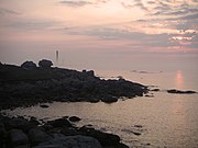
Sunset - Left in the picture: The lighthouses on the Île Vierge
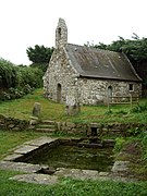
Chapel of Prad-Paol


Tourism and leisure
Plouguerneau has a tourist attraction especially in summer due to its beaches. Fireworks are regularly presented from the individual districts. All kinds of events such as wine tastings, bingo evenings and dance courses take place in the “Salle Jean-Tanguy”.
Town twinning
A town partnership has existed with Edingen-Neckarhausen ( Baden-Württemberg ) since 1967. Further partnerships exist with St Germans and Tideford in England .
literature
- Le Patrimoine des Communes du Finistère. Flohic Editions, Volume 1, Paris 1998, ISBN 2-84234-039-6 , pp. 716-733.
Web links
- Presentation of the location ( memento from February 9, 2005 in the Internet Archive ) at igp-jumelage.de
- Press review and photos of the Pont du Diable