
Ploudaniel
|
Ploudaniel Plouzeniel |
||
|---|---|---|
.svg)
|
|
|
| region | Brittany | |
| Department | Finistère | |
| Arrondissement | Brest | |
| Canton | Lesneven | |
| Community association | Lesneven et Côte des Légends | |
| Coordinates | 48 ° 32 ′ N , 4 ° 19 ′ W | |
| height | 27-121 m | |
| surface | 46.28 km 2 | |
| Residents | 3,709 (January 1, 2017) | |
| Population density | 80 inhabitants / km 2 | |
| Post Code | 29260 | |
| INSEE code | 29179 | |
| Website | www.commune-ploudaniel.fr | |
.JPG) Mairie Ploudaniel |
||

Ploudaniel ( Breton Plouzeniel ) is a French commune in the Finistère department with 3709 inhabitants (as of January 1, 2017).
location
The municipality is located in northwest Brittany about 12 kilometers south of the Atlantic coast . The canton capital Lesneven is 4 kilometers north, Brest 20 kilometers southwest and Paris about 480 kilometers east.
traffic
In Landerneau and Brest are the next departures of the highway E 50 ( Rennes - Brest) and regional stations on the railway line Brest - Rennes and Brest - Nantes .
The regional airport Aéroport de Brest Bretagne is 14 kilometers southwest.
Population development
| year | 1962 | 1968 | 1975 | 1982 | 1990 | 1999 | 2008 | 2017 |
| Residents | 2630 | 2511 | 2558 | 3044 | 3406 | 2572 | 3683 | 3709 |
| Sources: Cassini and INSEE | ||||||||
Attractions
- Saint-Yves church
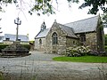
- Saint-Éloy Chapel
- Chapel of Sainte-Pétronille
- Trébodennic mansion
See also: List of Monuments historiques in Ploudaniel
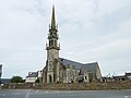
Saint-Yves church

Saint-Éloy Chapel
Chapel of Sainte-Pétronille

Trébodennic mansion


.JPG)
Parish partnership
Ploudaniel has established a community partnership with the French community of Fréland in the Haut-Rhin department .
literature
- Le Patrimoine des Communes du Finistère. Flohic Editions, Volume 1, Paris 1998, ISBN 2-84234-039-6 , pp. 769-774.