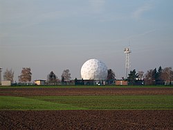
Mercator barracks
|
|
|||
|---|---|---|---|

Radome of the Mercator barracks |
|||
| country | Germany | ||
| Landmark | Geo sphere | ||
| local community | Euskirchen | ||
| Coordinates : | 50 ° 40 ′ N , 6 ° 46 ′ E | ||
| Opened | 1936-1938 | ||
| Stationed troops | |||
|
|
|||
| Old barracks names | |||
| before 1985 1951-1970 |
Radio barracks Selzate barracks |
|
|
|
Location of the Mercator barracks in North Rhine-Westphalia |
|||
The Mercator barracks was from 1936 to 1938 as part of the Wehrmacht Enhancements to the woman Straße in Euskirchen built (Rheinland).
After the Second World War , it was initially used to accommodate families who had become homeless as a result of the war. Until 1950, 41 families with 181 people were still housed there. Since 1951 the Belgian army used the barracks and expanded them. During this time it was called "Selzate Barracks". The German long-distance communications company has been using the barracks since 1970 and in 1971 the Bundeswehr Big Band set up its location here. It was also known as the "radio barracks". In 1985 the barracks was greatly expanded and rebuilt and received its current name, named after the geographer and cartographer Gerhard Mercator . On July 10, 1985, the Office for Military Geosciences (AMilGeo) moved into the Mercator barracks, which, after merging with the Office for Defense Geophysics, became the Office for Geoinformation of the Bundeswehr (AGeoBw) since 2014 the Center for Geoinformation of the Bundeswehr (ZGeoBw).
The NATO satellite ground station , popularly known as the Geo-Sphere , has almost become a landmark and is clearly visible from afar.
