Merla
|
Merla Мерла |
||
| Data | ||
| location | Ukraine | |
| River system | Dnepr | |
| Drain over | Worskla → Dnieper → Black Sea | |
| source | near Ryazne ( Рясне ), Zolochiv Raion , Kharkiv Oblast 50 ° 16 ′ 48 ″ N , 35 ° 47 ′ 42 ″ E |
|
| muzzle | in Poltava Oblast in Vorskla Coordinates: 49 ° 52 ′ 23 " N , 34 ° 40 ′ 18" E 49 ° 52 ′ 23 " N , 34 ° 40 ′ 18" E
|
|
| length | 116 km | |
| Catchment area | 2030 km² | |
| Small towns | Bohoduchiw , Huty , Krasnokutsk , | |
| Communities | Sabrody | |
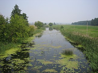
The Merla (Ukrainian Мерла ; Russian Мерла / Merlja ) is a non-navigable, 116 km long left tributary of the Vorskla in northern Ukraine and thus belongs to the river system of the Dnieper . Its catchment area has an area of 2030 km².
The source of the Merla is near the village of Ryazne ( Рясне ) in the west of Zolochiv Raion in the northwest of Kharkiv Oblast . It is dammed several times and is used for the drinking water supply and for irrigation. The largest tributary is the 43 km long Mertschyk ( Мерчик ) flowing in from the left .
On February 20, 1709, the battle at Krasnokutsk between Swedish and Russian troops took place on the river.
Web links
Commons : Merla - collection of images, videos and audio files
Individual evidence
- ↑ Merla in the Ukrainian Soviet Encyclopedia at leksika.com.ua (Ukrainian), accessed December 18, 2015
