
Metro de Santiago


The subway network in the Chilean capital Santiago de Chile ( Spanish: Metro de Santiago de Chile ) is the largest subway network in South America and the third oldest after Buenos Aires and São Paulo and connects large parts of the capital region. It currently has 136 underground stations on around 140 kilometers of route network. 225 trains are available for use on the six lines. They were supplied by Alstom , Concarril and CAF . (As of autumn 2018)
The operator is Empresa de Transporte de Pasajeros Metro SA , usually referred to as Metro SA . It is a stock corporation, but its capital is entirely in state hands.
The metro not only serves as a transport system, but is also a cultural attraction. Universidad de Chile metro station has a large mural by Mario Toral depicting the country's history. Other works of art can be found in the metro stations Baquedano, Bellas Artes, Santa Lucía (Portuguese azulejos, a gift from the Lisbon Metro), República and many other stations. The lights in the La Moneda station have recently been dimmed and are only illuminated by the new illuminated wall paintings.
Operating times
The Metro de Santiago runs Monday to Saturday from 6 a.m. to 11 p.m. and on Sundays from 8 a.m. to 11 p.m.
Tickets
A trip during rush hour ( hora alta ) with the single ticket ( Boleto Unitario ) costs 740 CLP and the rest of the time 660 CLP ( hora valle ) or early morning and late evening ( hora baja , tariff Rebajado ) 610 CLP (as of March 2016). Since February 10, 2007 there is a new multi-ticket system, which applies to both buses and metro ( Transantiago ). Payment is now made with the tarjeta BIP . This is held in front of the platform barrier reader and the fare is automatically debited. Single tickets will be withdrawn immediately. The current tariff is indicated by an illuminated sign.
There are no day tickets or similar, but in the Transantiago area it is possible to change the means of transport up to two times within 120 minutes. A reduced tariff of CLP 210 applies only to schoolchildren and students in Chilean institutions , which seniors can also use with some restrictions.
As of October 2019, the fare is 800 CLP. After the fare had been increased to CLP 830, protests broke out in Chile and the fare increase was withdrawn by Chile's President Sebastián Piñera in October 2019. Operations had to be discontinued across the board.
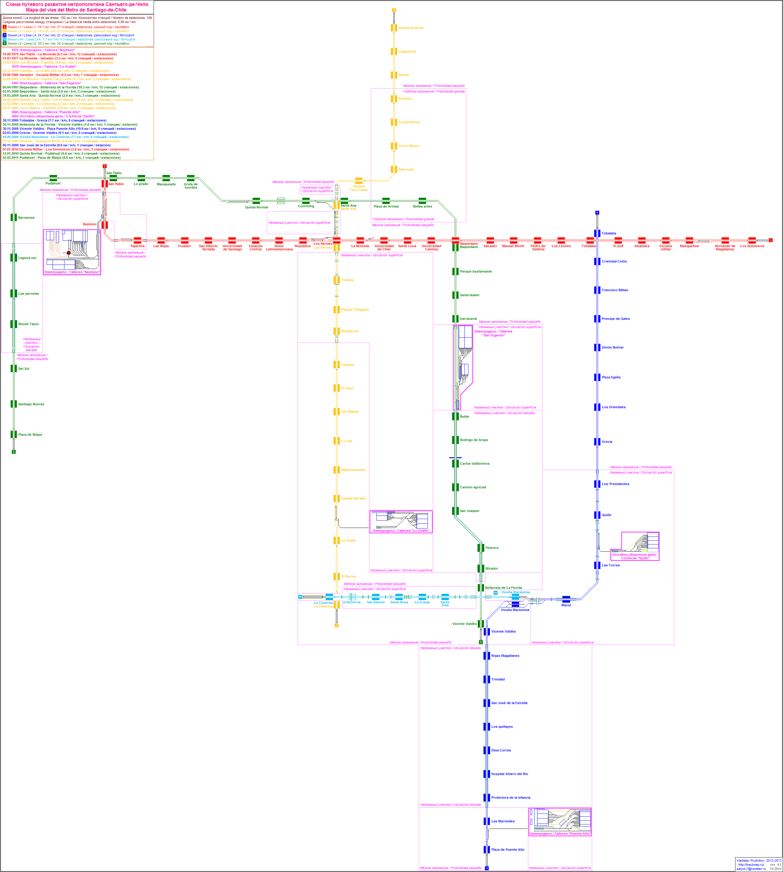
Development of the route network
The Metro de Santiago was designed in 1968 during the reign of Eduardo Frei Montalva and opened on September 15, 1975 by dictator Augusto Pinochet . It was built by a French- Chilean consortium BCEOM SOFRETU CADE , which had previously won an international tender.
First of all, the system known from the Paris metro was used with additional pneumatic tires on concrete runways outside the regular- gauge running rails with guidance and power supply via busbars coated from the side on both sides .
The technical unit of the route network was soon lost, however, lines 4 and 4A were built as classic double-rail systems without additional pneumatic tires and busbars arranged on one side and coated from above. Line 6 also received overhead lines and wagons with roof pantographs . Not all routes run in the tunnel, on lines 2, 4, 4A and 5 there are ground-level and elevated sections.
line 1

The first section of Line 1 was opened in 1975 as the first underground line in Santiago and runs from San Pablo under the prestigious main street of Santiago, the Avenida del Libertador Bernardo O'Higgins to La Moneda . In 1977 this line was extended to Salvador station , in 1980 to Escuela Militar and in 2010 to Los Dominicos .
Line 2

The line 2 was established in March 1978 as the second metro line on the stretch between Los Héroes and Franklin opened. In December of the same year this line was extended to Lo Ovalle station in 1987 to Puente Cal y Canto and in September 2004 to Cerro Blanco . On December 22, 2004, the southern extension to the La Cisterna station was opened. This line completed the first phase of the metro's expansion during the reign of Ricardo Lagos Escobar. Line 2 has been running in the north to Vespucio Norte since December 2006 .
Line 3

The line 3 went as second fully automated and driverless subway line in Santiago on January 22, 2019 operation. It connects Los Libertadores in the north of the city with La Reina in the east through the districts of Conchalí, Independencia, Santiago Centro and Ñuñoa. This made it possible to change to line 1 in Universidad de Chile, to line 2 in Cal y Canto, to line 5 in Plaza de Armas and Irarrázaval, to line 6 in Ñuñoa and to line 4 in Plaza Egaña. The line has its own workshop in Los Libertadores; the eastern end point is Fernando Castillo Velasco.
There are 18 stations on the 21.7 km long route. A trip takes 30 minutes. The planners expect around 245,000 users per day.
22 five-car trains supplied by CAF are used on this line . The 120 meter long trains have a capacity of 1285 passengers and are designed for a top speed of 80 km / h.
In 2022, a route extension with three stations from Los Libertadores to Plaza de Quilicura station in the northwest is to go into operation. When lines 7, 8 and 9 go into operation in 2026, there will be further transfer options at the Puente Cal y Canto, Matta and Chile España stations.
Line 4

The Line 4 was opened as a classic double-rail with top swept busbars of 2005. The workshop, which also looks after the wagons on Line 4A, is located between the Quillín and Las Torres stations.
Line 4A

The line 4A branches at the station Vicuña Mackenna from the line 4 and runs predominantly above ground on the median strip of southern beltway. It is the shortest line, the system with steel wheel sets and busbars painted from above corresponds to line 4. The line does not touch the city center, but runs tangentially from the La Cisterna business center in the south of the city to the suburb of Puente Alto .
Line 5


The line 5 was in April 1997 as the third metro line will be put into operation. Its first section led from the Baquedano station to Bellavista de La Florida . In March 2000 it was extended to Santa Ana , in March 2004 to Quinta Normal , 2010 to Pudahuel and 2011 to Plaza de Maipú . This terminus is under the Plaza de Armas de Maipú in Maipú .
There are 30 stations along the 30 km long route, which are located in the municipalities of Maipú , Pudahuel , Lo Prado , Quinta Normal , Santiago de Chile , Providencia , Ñuñoa , Macul , San Joaquín and Florida .
Line 6


The Line 6 was taken in November 2017 as the first fully automated, driverless metro line in operation. In addition to transfer options to lines 1, 2, 3 and 5, there is a transition to the Metrotren Nos regional train line at the Lo Valledor stop . The 15.3 km long route has ten stations. Like that of lines 4 and 4A, the line is a standard-gauge two-rail system, but the power supply is provided via an overhead contact line in the form of overhead conductor rails. The workshop of line 6 is west of the terminus Cerillos.
The Spanish company CAF supplied 15 continuously accessible five-car trains of the AS 2014 series with a capacity of 1285 passengers for this line.
Chronology: Commissioning of the individual route sections
| line | length | Stations | opening | Type | |
|---|---|---|---|---|---|
|
|
San Pablo - La Moneda | 8.2 km | 12 | Sep 1975 | tunnel |
|
|
La Moneda - Salvador | 3.2 km | 5 | Mar 1977 | tunnel |
|
|
Los Héroes - Franklin | 4.9 km | 4th | Mar 1978 | at ground level |
|
|
Franklin - Lo Ovalle | 4.8 km | 6th | Dec 1978 | tunnel |
|
|
Salvador - Escuela Militar | 4.5 km | 6th | Aug 1980 | tunnel |
|
|
Los Héroes - Santa Ana | 0.7 km | 1 | Jul 1986 | trough |
|
|
Santa Ana - Puente Cal y Canto | 1 km | 1 | Sep 1987 | Trough / tunnel |
|
|
Baquedano - Bellavista de La Florida | 10.3 km | 11 | Apr 1997 | viaduct |
|
|
Baquedano - Santa Ana | 2.8 km | 2 | Mar 2000 | tunnel |
|
|
Santa Ana - Quinta Normal | 2 km | 2 | Mar 2004 | tunnel |
|
|
Puente Cal y Canto - Cerro Blanco | 1.6 km | 2 | Sep 2004 | tunnel |
|
|
Lo Ovalle - La Cisterna | 2.1 km | 2 | Dec 2004 | tunnel |
|
|
Bellavista de La Florida - Vicente Valdés | 1.6 km | 1 | Oct 2005 | tunnel |
|
|
Vicente Valdés - Plaza de Puente Alto | 10.9 km | 9 | Oct 2005 | viaduct |
|
|
Tobalaba - Grecia | 7.7 km | 8th | Dec 2005 | tunnel |
|
|
Cerro Blanco - Einstein | 1.9 km | 2 | Dec 2005 | tunnel |
|
|
Grecia - Vicente Valdés | 6.1 km | 5 | Mar 2006 | at ground level |
|
|
Vicuña Mackenna - La Cisterna | 7.7 km | 6th | Jul 2006 | at ground level |
|
|
Einstein - Vespucio Norte | 2.4 km | 3 | Dec 2006 | tunnel |
|
|
San Jose de La Estrella | 0 km | 1 | Nov 2009 | at ground level |
|
|
Escuela Militar - Los Domínicos | 4 km | 5 | Jan 2010 | tunnel |
|
|
Quinta Normal - Pudahuel | 6.8 km | 5 | Jan 2010 | tunnel |
|
|
Pudahuel - Plaza de Maipu | 8.0 km | 7th | Feb 2011 | Tunnel / elevated |
|
|
Cerrillos - Los Leones | 15.3 km | 10 | Nov 2017 | tunnel |
|
|
Los Libertadores - Fernando Castillo Velasco | 21.7 km | 18th | Jan 2019 | tunnel |
|
|
La Cisterna - El Pino Hospital | 5 km | 4th | 2023 | tunnel |
|
|
EFE Quilicura - Plaza de Quilicura | 3.8 km | 3 | 2023 | tunnel |
|
|
Isidora Goyenechea | 1.4 km | 1 | 2026 | tunnel |
|
|
Brazil - Estoril | 24.8 km | 19th | 2026 | tunnel |
|
|
Los Leones - Puente Alto | 20 km | 14th | 2028 | tunnel |
|
|
Santa Lucía - La Pintana | 17 km | 12 | 2028 | tunnel |
|
|
Plaza de Puente Alto - Bajos de Mena | 4.2 km | 3 | 2028 | tunnel |
Transantiago

In February 2007, a combined public transport system consisting of metro and buses called Transantiago was put into operation. The main goal was to improve the traffic and environmental situation by removing the many small buses, which were also heavily responsible for the smog pollution, and replacing them with larger buses in a coordinated network of routes. The metro was viewed as a baseline network and feeder bus lines were set up. Furthermore, a uniform zone tariff was introduced to facilitate the use of several means of transport.
The system started with difficulties because there were too few buses in use at the beginning and the metro was chronically overcrowded. The first time was chaotic, there were protests, the reputation of the government under President Bachelet sank noticeably and solely because of the new transport system. The number of metro passengers rose suddenly from 1.3 to 2.2 million per day, which resulted in a standing room density of 6 people / m². In Germany, 4 people / m² is normally the highest value.
Operational peculiarities
Due to the high load on the routes and the train headway time of two minutes, an express system was introduced in November 2008 during rush hour, in which the trains stop alternately. You drive through at roughly every second station. The trains marked with red stop at the stations marked red , the green trains stop accordingly at the green stations. Both types of train stop at transfer stations. This measure allows more trains to be used. The express system is currently in use on lines 2, 4 and 5.
Expansion and planning
Line 7

The construction of this line was announced in 2017. It will run parallel to line 1 over a large area. It is expected that this will relieve Line 1. There are transfer options to lines 1, 2, 3, 5 and 6. Commissioning is scheduled for 2026.
Line 8

The new line 8 will connect Providencia with the eastern section of the Puente Alto district and will benefit the municipalities of Ñuñoa, Macul and La Florida, which run through Avenida Los Leones, José Pedro Alessandri, La Florida and Camilo Henríquez. is connected to lines 1, 3, 4 and 6. It should go into operation by 2026.
Line 9

Line 9, the completion of which is also announced for around 2026, will connect the municipality of La Pintana , located in the south of Greater Santiago, with 200,000 inhabitants with the actual core of Santiago. The 17 km long route will have 12 stops and connect six municipalities. There are transfer options to lines 1, 3, 4A and 6.
Additional stations on existing routes
Some new train stations are to be built on existing underground lines:
- Libertad on Line 5 between Quinta Normal and Cumming stations
- Echeverría on line 4A between La Cisterna and San Ramón stations .
Web links
- Official operator site
- Metro de Santiago fansite
- Urbanrail.net
- http://trackmap.ru/img/tm_santiago.png
Individual evidence
- ↑ President Piñera gives in - protests are having an impact - Chile's subway prices are not rising. In: srf.ch . October 20, 2019, accessed October 20, 2019 .
- ↑ Chile's president withdraws subway tariff increase after protests. In: rt.com . October 20, 2019, accessed October 20, 2019 .
- ↑ metro-report.com metro-report.com of November 3, 2017 (English), accessed on October 16, 2018.
- ↑ [1] twitter.com (Spanish), accessed on October 21, 2018