
Quinta normal
| Quinta normal | ||
|---|---|---|
|
Coordinates: 33 ° 26 ′ S , 70 ° 42 ′ W .
|
||
| Basic data | ||
| Country | Chile | |
| region | Metropolitan Region of Santiago | |
| City foundation | June 22, 1915 | |
| Residents | 93,904 (2008) | |
| City insignia | ||
|
|
||
| Detailed data | ||
| surface | 12.4 km 2 | |
| Population density | 7,573 inhabitants / km 2 | |
| prefix | +56 2 | |
| Time zone | UTC −4 | |
| Website | ||
 |
||

Quinta Normal is a municipality in Chile . It belongs to Greater Santiago and is centrally located to the west of the historic center. At 12.4 square kilometers, it is one of the smaller communities in Santiago. The population is 94,000 (2008 estimate) with a falling trend and an increasing proportion of the elderly. Economic activities in the municipality are concentrated in trade and industry.
history
Industry is displacing agriculture
Around 1850 the area of today's Quinta Normal was a sparsely populated agricultural zone outside of Santiago. There were numerous farms around today's Carrascal and Mapocho streets. The extension of San Pablo Street was joined by the path that then connected Santiago with Valparaíso , and there were already more houses there.
As part of the expansion of the railway network, the Estación Yungay freight station was built in 1888 on the western outskirts of the city near the intersection of today's Matucana and Mapocho streets, to which a passenger station was added in 1905. This station was an attraction for new, extensive industrial settlements in the area of today's municipality of Quinta Normal. Over time, thirteen large companies settled there. Including six chemical plants that produced sulfuric and hydrochloric acid and heavily contaminated their surroundings. The workers came with industry and settled in the vicinity. The result was an industrial and working-class district that contemporaries described as "sad", "remote" and "terrible". There was no public administration presence there, no police, only dirt roads and the postmen did not dare to go there.
The administration adapts to the development
The area belonged to the then municipality of Las Barrancas. Their administration, which was based on rural structures, was completely overwhelmed by keeping this rampant westward expansion of Santiago in order. In order to solve the administrative problem, two municipalities were formed from the urbanising area by splitting off.

In 1915 first the community of Quinta Normal. It probably comprised the zone south from San Pablo to the Alameda and was named after the Quinta Normal de Agricultura , an agricultural test site that was created there in 1842. And then in December 1916 the municipality of Yungay, which presumably comprised the zone north of San Pablo and in the west extended to the Las Rejas road. Yungay then had 3661 inhabitants. For the first time city ordinances were issued and roads paved.
In 1927 street lighting was installed for the first time, a police subordinate to the city administration was appointed and neighborhood organizations were set up. In January 1930, the two communities were merged into one community under the name Quinta Normal .
Cityscapes
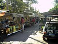
Weekly market on Victorino Laynez Street.

Typical older row houses on Francisco Javier Street.

Museo Nacional de Historia Natural de Chile in the park Quinta Normal. (The park is now part of the Santiago municipality)


Web links
Individual evidence
- ↑ a b Different dates are mentioned in various publications by government agencies: June 22, 1915 (city administration and statistical office), October 6, 1915 (Ministry of the Interior)
- ↑ a b c Datos Historícos. (PDF) Ilustre Municipalidad de Quinta Normal. Secretaría Comunal de Planificación, 2004, p. 76 , accessed on March 28, 2010 (Spanish).
- ↑ a b c Dirección de Estadística y Censos (ed.): XIII censo de población, 29 de noviembre de 1960 . Santiago de Chile 1964, p. 4 (Spanish, books.google.com [accessed March 29, 2010] limited preview).
- ↑ a b c Quinta Normal. Gobierno de Chile - Ministerio del Interior, archived from the original on August 3, 2007 ; Retrieved April 4, 2010 .
- ↑ Quinta Normal. In: Ficha Comunal. Gobierno de Chile - Ministerio del Interior, archived from the original on November 29, 2012 ; Retrieved April 4, 2010 .
- ↑ Censos. ( Flash ; 66 kB) Instituto Nacional de Estadísticas, accessed on March 28, 2010 (Spanish).
- ^ Raúl Irarrázaval Covarrubias: Santiago. un plan para una ciudad armoniosa . Ediciones Universidad Católica de Chile, Santiago de Chile 1985, p. 334 (Spanish).
- ↑ Historia del Ramal Yungay a Mapocho. Archived from the original on July 16, 2007 ; Retrieved April 3, 2010 (Spanish).
- ↑ Armando de Ramón (1927-2004): Santiago de Chile (1541-1991) . Historia de una sociedad urbana. Ediciorial Sudamericana Chilena, Santiago de Chile 2000, ISBN 956-262-118-9 , pp. 287 (Spanish, memoriachilena.cl ( memento from September 17, 2012 in the web archive archive.today )).
- ↑ Comuna Quinta Normal - Una visión historica. Archived from the original on January 20, 2013 ; Retrieved April 3, 2010 .