Minna-shima (Motobu)
| Minna-shima | ||
|---|---|---|
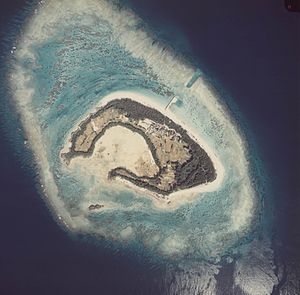
| Aerial photo, 1977 | ||
| Waters | East China Sea | |
| Archipelago | Okinawa Islands | |
| Geographical location | 26 ° 38 '50 " N , 127 ° 48' 57" E | |
|
|
||
| length | 1.1 km | |
| width | 650 m | |
| surface | 47 ha | |
| Highest elevation | 26.9 m | |
| Residents | 39 (January 1, 2015) 83 inhabitants / km² |
|
Minna-shima ( Japanese 水 納 島 ) is a Japanese island in the Okinawa Islands .
geography
The 0.47 km² island is 3.3 km west of Sesoko-jima and 5.7 km west of the Motobu Peninsula on the island of Okinawa . The highest elevation is 26.9 m. The island is surrounded by an atoll . It is also called Croissant Island because of its shape .
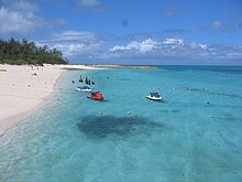
The island with its 39 inhabitants in 25 households belongs to the Sesoko district of the Motobu municipality . Despite this small population, there is a primary and secondary school with one pupil and eight teachers each (as of 2018). The main products of the community are daikon radish and carrots. In addition, the island lives from tourism and was visited by more than 60,000 people in 2006.
Individual evidence
- ↑ a b c d 指定 離島 ・ 指定 離島 一 覧 . (PDF) In: 離島 関係 資料 (平 成 28 年 1 月) . 沖 縄 県 企 画 部 地域 ・ 離島 課 (“Land and Islands Unit, Planning Department, Okinawa Prefecture”), January 2016, p. 1 , accessed on 1. August 2016 (Japanese).
- ↑ official topographic map
- ↑ a b 水 納 小 中 学校 :: 学校 紹 介 . Minna Elementary and Middle School, accessed March 25, 2019 (Japanese).
- ↑ 6 水 納 島 (本部 町) . (No longer available online.) In: 島 の デ ー タ . Okinawa Prefecture, archived from the original on March 4, 2016 ; Retrieved December 15, 2012 (Japanese).


