Mistastin Lake
| Mistastin Lake | ||
|---|---|---|

|
||
| Landsat image | ||
| Geographical location | Labrador in Newfoundland and Labrador (Canada) | |
| Drain | Mistastin River → Head Brook → Cabot Lake → Kogaluk River | |
| Islands | Horseshoe Island | |
| Location close to the shore | Nain | |
| Data | ||
| Coordinates | 55 ° 53 ′ N , 63 ° 18 ′ W | |
|
|
||
| Altitude above sea level | 338 m | |
| surface | 145 km² | |
| length | 19 km | |
| width | 12 km | |
| Catchment area | 1350 km² | |
|
particularities |
||

|
||
| Mistastin Lake | ||
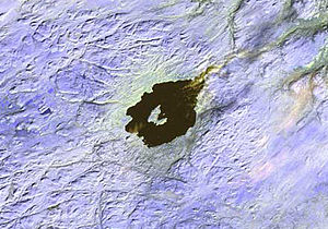
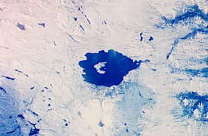
Mistastin Lake is a lake in the Labrador sub-province of Newfoundland and Labrador in Canada .
The approximately circular lake has a diameter of 16 km and lies at an altitude of 338 m .
At the northeast end, the Mistastin River drains the lake to the northeast. The water finally reaches Voisey's Bay and the Atlantic Ocean via Head Brook , Cabot Lake and Kogaluk River .
The lake lies in an impact crater , which was formed 36.4 ± 4 million years ago in the Eocene and which originally had a diameter of 28 km.
The geological structure has a crater rim from heights up to 670 m above sea level. The diameter is 26 km. In the center is Mistastin Lake, in the middle of which is the arched island of Horseshoe Island , which is the relic of a central mountain.
Web links
Individual evidence
- ^ Government of Canada: Historical Hydrometric Data Search Results: Station 03NE007
- ↑ Earth Impact Database - Mistastin ( Memento of the original from March 3, 2016 in the Internet Archive ) Info: The archive link was inserted automatically and has not yet been checked. Please check the original and archive link according to the instructions and then remove this notice.
