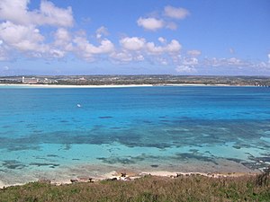
Miyako Islands
| Miyako Islands | ||
|---|---|---|
| Yonaha mae bay | ||
| Waters | Pacific Ocean | |
| archipelago | Ryūkyū Islands | |
| Geographical location | 24 ° 43 ′ N , 125 ° 1 ′ E | |
|
|
||
| Number of islands | 12 (≥ 1 ha) | |
| Main island | Miyako-jima | |
| Total land area | 255.77 km² | |
| Residents | 53,289 (October 1, 2019) | |
| Map of the Sakishima Islands, with the Miyako Islands to the east | ||
The Miyako Islands ( Japanese 宮 古 列島 Miyako-rettō , German 'Miyako-Inselkette' , also: 宮 古 諸島 Miyako-shotō , German 'Miyako-Inselgruppe' ) are an island group of the Japanese prefecture Okinawa .
geography
The Miyako Islands are 240 km southwest of the main island of Okinawa Hontō in Okinawa Prefecture and 34 km northeast of Ishigaki-jima Island in the Yaeyama Islands . With the latter group of islands, the Miyako Islands together form the Sakishima Islands .
Islands
The archipelago consists of the following 12 islands with an area of at least one hectare, the largest 8 of which are inhabited:
| Surname | Japanese | Area [km²] | Height [m] | local community | Coordinates |
|---|---|---|---|---|---|
| Miyako-jima | 宮 古 島 | 159.26 | 114.8 | Miyakojima | 24 ° 47 ' N , 125 ° 19' E |
| Irabu-jima | 伊 良 部 島 | 29.08 | 89.0 | Miyakojima | 24 ° 50 ′ 10 " N , 125 ° 11 ′ 20" E |
| Tarama-shima | 多 良 間 島 | 19.75 | 34.2 | Tarama | 24 ° 39 ′ 26 " N , 124 ° 41 ′ 58" E |
| Shimoji-jima | 下地 島 | 9.54 | 21.6 | Miyakojima | 24 ° 49 ′ 10 " N , 125 ° 9 ′ 15" E |
| Kurima-jima | 来 間 島 | 2.84 | 47.3 | Miyakojima | 24 ° 43 ′ 17 " N , 125 ° 14 ′ 51" E |
| Ikema-jima | 池 間 島 | 2.83 | 28 | Miyakojima | 24 ° 55 ′ 50 " N , 125 ° 14 ′ 38" E |
| Minna-shima | 水 納 島 | 2.15 | 13.2 | Tarama | 24 ° 45 ′ 11 " N , 124 ° 41 ′ 48" E |
| Ōgami-jima | 大 神 島 | 0.24 | 74.4 | Miyakojima | 24 ° 54 ′ 59 " N , 125 ° 18 ′ 28" E |
| Suidō-kojima | 水道 小島 | 0.05 | Miyakojima | ||
| Island (north of Yonaha Bay) | シ マ (与 那覇 湾 北) | 0.01 | Miyakojima | 24 ° 47 ' N , 125 ° 16' E | |
| Island (in Yonaha Bay) | シ マ (与 那覇 湾 奥) | 0.01 | Miyakojima | 24 ° 46 ' N , 125 ° 16' E | |
| Island (north of the Irabu waterway) | シ マ (伊 良 部 水道 北) | 0.01 | Miyakojima | ||
|
|
|||||
The total land area of all islands is 256 km².
Administrative division
Tarama-jima and Minna-jima form the district of Miyako with the village of Tarama as the only place with 1113 inhabitants (as of October 1, 2019) on 22 km² and thus a density of 51 people / km² .
All the other islands in the group form the city of Miyakojima since October 2005 . It has 52,176 inhabitants (as of October 1, 2019) on 205 km² of land and thus has a population density of 255 people / km².
The total number of inhabitants is 53,289 inhabitants with a population density of 208 people / km².
Culture
The Miyako language or dialect of the archipelago belongs to the Ryūkyū languages . A distinction is made between the dialect groups Irabu and Miyako and most closely resembles the Yaeyama language or dialect. A special feature within the Japanese language family are consonants at the end of syllables.
Economy and tourism
Mainly sugar cane is grown , the fishing mainly brings Katsuo ( Bonito ) ashore.
Miyako-jima in particular is a popular holiday destination; From Ikema-jima diving trips to the coral reef Yabuji (also Yabushi or Yaebushi ) are offered. The coral reef measures 15 km in north-south direction and 10 km in east-west direction.
traffic
There are airfields on Miyako-jima, Tarama-shima and Shimoji-jima. The latter, however, no longer offers regular services. There are regular ferry connections from Hirara on Miyako-jima to Irabu-jima, Tarama-shima, Ishigaki-jima and Naha .
Web links
- Miyako Islands Part on Okinawa Island Web (Japanese)
Individual evidence
- ↑ 指定 離島 ・ 指定 離島 一 覧 . (PDF) In: 離島 関係 資料 (平 成 28 年 1 月) . 沖 縄 県 企 画 部 地域 ・ 離島 課 ("Land and Islands Unit, Planning Department, Okinawa Prefecture"), January 2016, p. 1 , accessed on 4. August 2016 (Japanese).


