Ishigaki-jima
| Ishigaki-jima | ||
|---|---|---|
| Ishigaki-jima, at the top right | ||
| Waters | Pacific / East China Sea | |
| Archipelago | Yaeyama | |
| Geographical location | 24 ° 29 ′ N , 124 ° 13 ′ E | |
|
|
||
| length | 35 km | |
| width | 20 km | |
| surface | 222.25 km² | |
| Highest elevation |
Omotodake 526 m |
|
| Residents | 44,907 202 inhabitants / km² |
|
Ishigaki-jima ( Japanese 石垣島 , literally: stone fence island ) is the main island of the Yaeyama Islands with 44,907 inhabitants on 222.25 km² . It is the third largest island (after Okinawa and Iriomote-jima ) in the Japanese prefecture of Okinawa. The distance to Tarama-shima of the Miyako Islands in the northeast is about 32 km, to the main island of Okinawa in the prefecture of the same name about 370 km, to the Chinese island state of Taiwan it is only about 230 km. The entire island belongs to the area of the city of Ishigaki in the south of the island.
Parts of the island and coastal waters have been part of the Iriomote Ishigaki National Park since 2007 .
topography
The coastline is more structured in the north-west and forms a very long spur in the north-east, which is only approx. 300 m narrow at one point. The soil shape is mostly wavy, higher elevations can be found mainly in the north of the island's hull and in the headlands. The Omotodake ( 於 茂 登岳 ) is the highest mountain in Okinawa Prefecture at 526 meters . The island is crossed by two larger streams, some of which are fed by three reservoirs.
climate
In the summer months the daytime temperatures are around 35 ° C, in the winter months around 12 ° C. Like all Ryūkyū Islands , Ishigaki-jima is often hit by typhoons from May to September .
economy
The islanders have lived from time immemorial on fruit growing (pineapple, mandarins), farming, cattle breeding and fishing, especially the katsuo ( bonito ). Nowadays tourism is an important source of income for the island. Several hotels, beaches, coral reefs, numerous restaurants, the ferry port as a transit station to the other islands of the Yaeyama group and, last but not least, a golf course attract many visitors to Ishigaki-jima.
Culture
The Yaeyama language is one of the Ryūkyū languages .
Special
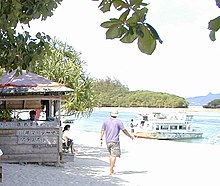
Particularly worth seeing are the Kabira Bay ( 川 平 湾 , Kabira-wan ), the Tamatori Headland ( 玉 取 崎 , Tamatori-zaki ) and the Yaeyama Museum, Japan's southernmost museum. The swimming season in the sea on Ishigaki-jima starts in March, one month earlier than on the main island of the prefecture.
The town hall of the neighboring municipality of Taketomi is also located on Ishigaki-jima Island, where around 90% of the inhabitants of the Yaeyama Islands live.
Ishigaki has been used as a location for several films or Japanese television drama . For example, Ishigaki-jima was together with Mimami-daitō the location of the film Kamigami no Fukaki Yokubō by Shōhei Imamura .
traffic
The island is well developed for car traffic and rental cars are available. Daily flight connections from Ishigaki Airport are offered to Hateruma -jima , Yonaguni-jima , Miyako-jima , Naha , Kansai and Tokyo-Haneda , and there are ferry connections to all inhabited islands of the Yaeyama Islands . Taxis are also easy to come by. This means that the whole island can be visited in about three hours. Another good way to explore the island is by using scooters, which are much cheaper to rent than cars. The traffic is not particularly dangerous as people tend to drive cautiously.
See also
Web links
- Ishigaki-shi's website
- Ishigaki-jima part on the Japanese-language Okinawa Island web
- English blog with lots of information and pictures about Ishigaki ( Memento from December 5, 2014 in the Internet Archive )
- Japanese-language Ishigaki-jima page with live image
Individual evidence
- ↑ 島 面積 . (PDF; 136 kB) (No longer available online.) Kokudo Chiriin , October 1, 2015, archived from the original on June 15, 2016 ; Retrieved August 1, 2016 (Japanese).


