
Iriomote
| Iriomote | ||
|---|---|---|
 |
||
| Waters | East China Sea | |
| Archipelago | Yaeyama Islands | |
| Geographical location | 24 ° 20 ' N , 123 ° 47' E | |
|
||
| length | 29 km | |
| width | 19 km | |
| surface | 289.28 km² | |
| Highest elevation | Komidake 469.5 m |
|
| Residents | 2224 (March 31, 2011) 7.7 inhabitants / km² |
|

Iriomote or Iriomote-jima ( Japanese 西 表 島 ) is 289.28 km², the largest island in the Yaeyama group in Okinawa Prefecture , almost at the southwest end of the Japanese island chain. Due to its extraordinary biodiversity, Iriomote was also called "Galapagos of the East".
geography
Iriomote-jima is more south than Taipei and, at a distance of approx. 180 km, closer to Taiwan than to the main island of Okinawa Prefecture (approx. 430 km).
The majority of the island is under nature protection and is part of the Iriomote Ishigaki National Park (125 km² land area), which also includes the islands of Kuroshima , Kohama-jima and Taketomi-jima . The islands are administered by the municipality of Taketomi , with Iriomote being the main island of the municipality.
Between the latter two is Japan's largest coral reef. Its extension is 20 km in north-south direction, 15 km from east to west. About 21 km northwest of the island there is an active undersea volcano (last eruption in 1926).
population
Although the island has a larger area than the neighboring Ishigaki-jima, it is only sparsely populated with 2224 inhabitants in 1166 households (as of 2011) . The local dialect, a variant of the Yaeyama language , is now rarely used.
topography
The impassable interior of the island is consistently hilly with heights of up to 400 m, the mountain Komidake ( 古 見 岳 ) reaches 470 m.
Due to the high humidity (90% annual average), the large amounts of precipitation and heavy forest, Iriomote-jima is rich in water. There are 26 rivers with the Urauchigawa (18.8 km) as the longest river in Okinawa Prefecture at their head, followed by the Nakamagawa (13.5 km).
On the coast, steep rock faces alternate with sandy beaches. In some places you can find so-called “star sand ” ( hoshizuna , 星砂 ), which consists of the star-shaped calcareous skeletons of foraminifera from the surrounding coral reefs.
Flora and fauna
90% of the island is covered by subtropical jungle , in the lowlands of the estuary area there are mangrove swamps .
In 1965, the Iriomote Cat ( Prionailurus bengalensis iriomotensis , Jap. Iriomote-Yamaneko ) discovered one under protection of species related subspecies of Bengal , who lives only on this island. As a natural monument are also protected by the serpent eagle ( Spilornis cheela , Jap. Kanmuri-washi ), a turtle ( Cuora flavomarginata , Jap. Semaruhakogame ), a smooth lizard ( kishinouyei Plestiodon , Jap. Kishinoue-Tokage ) and non in the Yaeyama Island group Pit viper species ( Trimeresurus riukiuanus ) called Sakishima-habu . Their bite is fatal only in rare cases, in contrast to the venom of the larger pit vipers on the northern islands of the Ryukyu island chain. Many animal species of the extraordinary biodiversity on Iriomote are endemic , so they only occur here.
Settlement and transport
Two settlements, Uehara ( 上原 ) in the north and Ōhara ( 大 原 ) in the southeast, have boat connections to Ishigaki-jima Island (approx. 45 min), the nearest airport is on Ishigaki Island .
The only road leads from Shirahama in the northwest via Uehara along the north and east coast to Ōhara in the southeast. On the south and west coast as well as inland there are no passable roads.
history
For a long time only a few rice farmers and fishermen lived here in some places on the coast. Although the kingdom of Ryūkyū tried to force a more intensive development in the early modern times, the population was decimated again and again by the malaria, which had raged from ancient times . In 1879 the Ryukyu island chain was incorporated into the Japanese Empire by the Meiji government. Seven years later, the Mitsui Bussan company began dismantling the tertiary coal deposits on Iriomote. Since after three years only a third of the 200 miners deployed were still alive, the company was put on hold for a while. Another attempt was made in the 1920s. During the war years, not only locals but also convicts and workers from nearby Taiwan were forced to work in the pits. This phase ended with the defeat of Japan. In 1953 there was renewed dismantling, but this was abandoned in 1960 due to lack of profitability.
In the years under American occupation up to the return of Okinawa to Japan in 1972, malaria was successfully eradicated on Iriomote.
tourism
In contrast to the neighboring island of Ishigaki-jima, Iriomote offers only a few hotels and guest houses. The island is popular with divers because of the coral reefs. There are also excursions in the rivers by canoe or on foot along some hiking trails inland. In the latter case, however, the assistance of a local guide is advisable. In the north-east there are trips with carts pulled by water buffalos to the upstream sandbank Yufu-jima ( enen 布 島 ).
The southernmost thermal bath ( onsen ) in Japan was on Iriomote, but this has been closed for financial reasons.
See also
- Nansei-shotō
- Ryūkyū Islands
- List of islands in Okinawa Prefecture
- Sakishima Islands
- Iriomote Ishigaki National Park
literature
- Okinawa Kenritsu-Hakubutsukan: Iriomote-jima sōgō chōsa hōkokusho - shizen, kōko, rekishi, minzoku, bijutsu-kōgei [Comprehensive investigation report of the Okinawal Prefecture Museum on the island of Iriomote]. Naha, 2001 museums.pref.okinawa.jp (PDF; approx. 30 MB) 西 表 島 総 合 調查 報告 書
Web links
- Iriomotes website (Japanese)
- English-language Wikivoyage
Individual evidence
- ↑ a b c 第 1 指定 離島 ・ 島 し ょ ・ 人口 . (PDF) In: 離島 関係 資料 (平 成 24 年 1 月 . 沖 縄 県 企 画 部 地域 ・ 離島 課 (“Land and Islands Unit, Planning Department, Okinawa Prefecture”), January 2012, p. 2 , accessed December 13 2012 (Japanese).
- ↑ a b Wild Islands - Japan , TV documentary from the series "Wild Islands", ZDF 2014.
gallery

Tudumari-no-hama (Tsukigahama Beach)
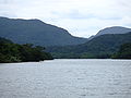
Urauchigawa

Mariyudō-no-taki , waterfall in the middle reaches of the Urauchigawa
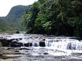
Kampire-no-taki , waterfall in the middle reaches of the Urauchigawa

Pinaisara-no-taki , waterfall in the north of the island

Mangroves at Nakamagawa


