
Kohama-jima
| Kohama-jima | ||
|---|---|---|
 |
||
| Waters | Pacific Ocean | |
| Archipelago | Ryūkyū Islands | |
| Geographical location | 24 ° 20 '24 " N , 123 ° 58' 49" E | |
|
||
| length | 4.5 km | |
| surface | 7.86 km² | |
| Highest elevation | Ōdake 99 m |
|
| Residents | 634 (January 1, 2015) 81 inhabitants / km² |
|
| main place | Kohama, Taketomi | |
 |
||

Kohama Island ( Japanese 小浜島 ; Yaeyama : Kumo / okinawisch : Kubama ) is an island of the community Taketomi , Okinawa . Kohama belongs to the group of Yaeyama Islands , has an area of 7.86 km² and has 634 inhabitants in 389 households.
On the island, which can be reached several times a day by ferry from Ishigaki , is the district of Kohama in the municipality of Taketomi .
Attractions
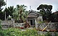
The outdoor shots of Churasan , a TV series that was very successful in Japan in 2001 , were shot on Kohama-jima . Therefore, the island is visited by a relatively large number of Japanese tourists. One of the main attractions is the Kohagurasō ( こ は ぐ ら 荘 ) house, built in the traditional style of the Ryūkyū Islands , where the main story took place . The house is surrounded by a wall of coral stone and, as was customary in the past, additionally hidden from view of passers-by by a wall between the courtyard gate and the house. This wall should also protect against evil spirits. Another typical feature is the hipped roof made of red tiles with a figure of the mythical animal Shīsā , which is also supposed to protect the house and its inhabitants. Another attraction of the island is a street east of the village, where numerous exterior shots of the series were also taken. Because it goes past sugar cane fields, it is known in Japan as Sugar Road .
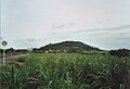
The highest point on the island is the 99 m high mountain Ufudaki, on the top of which there are stairs. A viewing pavilion was built here, from which there is a comprehensive panoramic view of the entire island as far as the neighboring island of Iriomote .
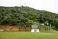
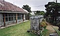
The local museum in the village is also worth seeing. a. agricultural implements and historical photos can be seen. On the east coast of Kohama-jima, a white gate rises up on the beach, which shows the entrance to a Shinto shrine. It consists of a stone under a particularly large tree and can be reached via a staircase with numerous white lilies blooming on either side.
Infrastructure
The only village on Kohama-jima has a modern school, an administration building, a few small shops and guest houses as well as restaurants. A large hotel complex was built just outside the village.
Impressions from Kohamajima
View to Ufudaki
Ufudaki mountain
The historic house of Kohagurasō

Main road

school
museum

The highway called Sugar Road
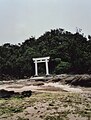
Entrance to the Shinto sanctuary on the east coast


Web links
- Congregation website (Japanese)
Individual evidence
- ↑ a b 指定 離島 ・ 指定 離島 一 覧 . (PDF) In: 離島 関係 資料 (平 成 28 年 1 月) . 沖 縄 県 企 画 部 地域 ・ 離島 課 (“Land and Islands Unit, Planning Department, Okinawa Prefecture”), January 2016, p. 1 , accessed on 1. August 2016 (Japanese).
- ↑ ryukyu-lang.lib.u-ryukyu.ac.jp
- ↑ Yamakei: Ryukyu Nansei Shoto. Tokyo 2003, ISBN 4-635-01718-4 , p. 111.
- ↑ Chris Taylor: Japan. Stefan Loose Verlag, Berlin 1998, p. 721.