
Hateruma
| Hateruma | ||
|---|---|---|
| Waters | East China Sea | |
| Archipelago | Yaeyama Islands | |
| Geographical location | 24 ° 3 '31 " N , 123 ° 46' 50" E | |
|
||
| length | 6 km | |
| width | 3 km | |
| surface | 12.77 km² | |
| Highest elevation | 59.5 m | |
| Residents | 540 (March 31, 2011) 42 inhabitants / km² |
|
| main place | Hateruma, Taketomi | |

Hateruma ( Japanese 波 照 間 島 , Hateruma-jima ) is the southernmost inhabited island of Japan with fewer than 540 inhabitants in 261 households (as of March 31, 2011) . Its area is 12.77 km² and the highest elevation is 59.5 m.
Tourism and the cultivation of sugar cane and pineapple form the economic basis of the island. Awanami, a liquor that is only made on Hateruma, is also distilled there . The water of Hateruma, the color of which is called Hateruma Blue in Japan , is extremely clear and the beaches are characterized by white sand. Since 1972 the island has been part of the Iriomote Ishigaki National Park .
Attractions
Hateruma is visited by a relatively large number of tourists - mostly day-trippers from the neighboring, larger island of Ishigaki - as the south coast of the island is the southernmost point of Japan, apart from the remote, uninhabited atoll Okino-Torishima . Additional attractions for Japanese tourists are the southernmost school and the southernmost police station in Japan. More Attractions:
The traditional architecture of the Ryukyu and Yaeyama Islands can still be found in many places in the only town in Haterum. Characteristic are houses with a hipped roof made of red tiles, on which a figure of the mythical creature King Shisar is enthroned. This figure is supposed to protect against evil spirits. Another typical feature is a massive wall made of sharp-edged coral rock that surrounds the house and property.
In the center of the village, not far from the park-like village square, there is also a monument to the freedom fighter Oyake Akahachi , who is said to have been born on Hateruma around 1500.
One of the most interesting structures on Hateruma is the watchtower called Kodomori , which was built from dark coral rock in the 17th century. It was used to observe the shipping traffic to and from Ishigaki. The top of the tower was one of the highest points on the otherwise rather flat island, so it was also used to transmit messages to Ishigaki with the help of beacons and smoke signals. The tower can be climbed and offers a beautiful view. On the small neighboring island of Kuroshima , a similar tower known as Puzumari is worth seeing .
On the south coast there is a monument that marks the southernmost point of all of Japan. The south coast of Hateruma is a steep coast made of sharp-edged rock with rough surf.
The north coast of Hateruma is a popular tourist destination because of its fine-grained sand and gently sloping beach. The water of Hateruma, whose color is called Hateruma Blue in Japan , is particularly clear here.
Infrastructure
Hateruma Airport is served by Ishigaki. Hateruma is also easy to get to with the ferries that run several times a day from Ishigaki. For day tourists, buses are available at the port for round trips, and you can also rent bicycles here, but all points of the island that are worth visiting can also be easily reached on foot. There are several small hotels, restaurants and guest houses available on the island. There are a few small shops for daily needs in the village.
Hateruma

Monument at the southernmost point of Japan

Hateruma Airfield
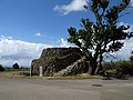
Kodomori Tower

South coast

Monument to Oyake Akahachi

Town center
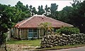
Traditional architecture
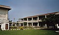
Southernmost school in Japan

Southernmost police station in Japan
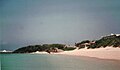
North coast
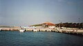
port


See also
literature
- Yamakei: Ryukyu Nansei Shoto . Tokyo 2003. ISBN 4-635-01718-4 , pp. 120-121
Web links
Individual evidence
- ↑ a b 第 1 指定 離島 ・ 島 し ょ ・ 人口 . (PDF) In: 離島 関係 資料 (平 成 24 年 1 月) . 沖 縄 県 企 画 部 地域 ・ 離島 課 (“Land and Islands Unit, Planning Department, Okinawa Prefecture”), January 2012, p. 2 , accessed on 13. December 2012 (Japanese).
- ↑ 波 照 間 島 . In: 世界 大 百科 事 典 第 2 版 at kotobank.jp. Retrieved December 31, 2012 (Japanese).