
Kuroshima (Taketomi)
| Kuroshima | ||
|---|---|---|
 |
||
| Waters | Pacific Ocean | |
| Archipelago | Ryūkyū Islands | |
| Geographical location | 24 ° 14 '17 " N , 124 ° 0' 32" E | |
|
||
| length | 4 km | |
| width | 3.5 km | |
| surface | 10.02 km² | |
| Highest elevation | 15 m | |
| Residents | 209 (January 1, 2015) 21 inhabitants / km² |
|
| main place | Kuroshima, Taketomi | |
 |
||

Kuroshima ( jap. 黒島 ; Yaeyama : Fishīma / okinawisch : Kurushima , dt "Black Island".), Also called Kuro known is an island of the community Taketomi , Okinawa . The Japanese name is stressed on the third from last syllable.
Kuroshima belongs to the group of Yaeyama Islands . From the air, the island resembles a heart and is therefore also known as the Heart Island . Since there are more cows than people on the island, it is sometimes marketed under the name "Island of Cows".
On the 10.02 km² island live (January 1, 2015) 209 inhabitants in 120 households. Livestock and tourism are of economic importance . The island is relatively flat, its highest point is 15 m. It is surrounded by a coral reef .
Attractions
Kuroshima has several attractions to offer:
- A lighthouse rises at the southern tip.
- In the Visitors' Center, not far from the west coast, there is an exhibition of historical photos, stuffed animals, agricultural implements and other items.
- The most interesting building on the island is the tower called Puzumari , not far from the visitor center. It was built from black coral rock at the time of the Ryukyu Kingdom and was used to monitor ship traffic to and from the neighboring island of Ishigaki . At that time its top was the highest point on the entire island. He sent messages to Ishigaki with beacons and smoke signals. Similar towers made of dark coral rock can also be found on other islands of the Yaeyama group, e.g. B. the Kodomori tower on Hateruma from the 17th century.
- The west coast of Kuroshima, Nakamoto Kaigan , is also worth a visit. Here you can see impressive coral stone formations washed out by the sea and a small Shinto shrine.
- In the middle of the island, not far from the school, there is another, albeit younger, tower that offers a wide panoramic view of the entire island.
- Further ruins of dark coral rock can be found, partly densely overgrown with different plants, widely scattered over the entire island.
- In the only village on the island, various houses in the traditional style of the Ryukyu Islands with a hipped roof have been preserved. Some of them are still surrounded by a wall made of sharp-edged, dark coral rock.
Infrastructure
Kuroshima can be reached several times a day by ferry from neighboring Ishigaki. At the small port in the north of the island there is a bike rental, but all interesting places on the island are within walking distance. In the only village there are several small guest houses ( minshuku ), a shop for daily needs and a post office that also serves as a savings bank.

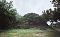
Typical landscape on Kuroshima

West coast Nakamoto Kaigan

Traditional architecture

Main street of the village
Puzumari tower

One of the numerous ruins

Tower in the center of the island
Individual evidence
- ↑ a b 指定 離島 ・ 指定 離島 一 覧 . (PDF) In: 離島 関係 資料 (平 成 28 年 1 月 . 沖 縄 県 企 画 部 地域 ・ 離島 課 (“Land and Islands Unit, Planning Department, Okinawa Prefecture”), January 2016, p. 1 , accessed August 1 2016 (Japanese).
- ↑ Yamakei: Ryukyu Nansei Shoto , p. 113. Tokyo 2003. ISBN 4-635-01718-4
Web links
- Information and pictures ( Memento from February 26, 2009 in the Internet Archive )