Moki Dugway

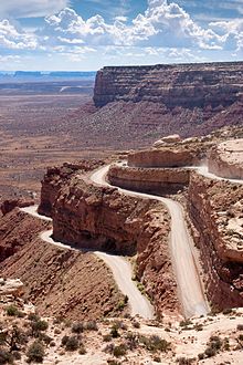
The Moki Dugway is a section of Utah State Route 261 in San Juan County in the southeast of the US state of Utah . The road overcomes a steep wall around 335 meters high over a distance of 4.8 kilometers. The street has been in the Bears Ears National Monument since 2016 . Coordinates: 37 ° 16 ′ 31.79 ″ N , 109 ° 56 ′ 24.14 ″ W.
Surname
The name Moki (also Mokee or Moqui ) comes from the Spanish word Moqui, with which the Spanish explorers of this region referred to the Pueblo Indians and the lost culture of the Anasazi . The dictionary of the American West defines Dugway as "a road through a hill country built for heavy haulage". It was a matter of negotiating a steep slope on wagon wheels. Deep furrows prevented the wheels from slipping sideways.
Route
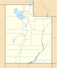
Location of the Moki Dugway in Utah |
Coming from the north, Utah State Route 261 reaches the edge of the Cedar Mesa , which drops there almost vertically for over 330 meters. The road runs here with a gradient of around 11% and tight hairpin bends in the steep face and arrives at the valley floor after around 5 kilometers. The upper part of the road is unpaved, but the lower part is paved. Most vehicles can drive the route. However, caution is advised with mobile homes and cars with trailers. The road is at least two lanes wide, but it has no hard shoulder, which makes it appear narrower.
From a parking lot at the highest point of the road, the Moki Dugway Overlook, there is a good view of the Valley of the Gods below. The little lonely house on the plain is the Bed and Breakfast in the Valley of the Gods. Originally it was called Lee's Ranch and is the only residential building in the 1460 km² Cedar Mesa Cultural and Recreational Management Area (" Cedar Mesa Cultural and Recreational Management Area "). Sleeping Ute Mountain near Cortez in Colorado can be seen on the horizon . In the southeast lies the Shiprock in New Mexico and in the south you can discover the Carrizo Mountains , while the typical table mountains of Monument Valley appear in the southwest.
At the beginning of the unpaved road section, another unpaved road leads west to Muley Point, about eight kilometers away , from which there is a view of the goosenecks of the San Juan River and the wide, sweeping valleys below. The table mountains of Monument Valley are on the horizon and John's Canyon can be seen in the foreground. There are warning signs: “Particular caution is required at the edge of the 400 meter high cliff. The road does not have a solid foundation at this point. If you can see puddles or damp spots, you should avoid them. If the road is damp or wet, do not drive any further. "
history
The Moki Dugway was built in the 1950s by Texas Zinc Minerals to transport uranium ore and vanadium from the Happy Jack Mine in Fry Canyon on Cedar Mesa via the Moki Dugway to a facility in Halchita near Mexican Hat for processing . Today there are no more encounters in the curves with ore-laden trucks.
Individual evidence
- ↑ a b c d e Moki Dugway ( Memento of the original from September 7, 2012 in the Internet Archive ) Info: The archive link was inserted automatically and has not yet been checked. Please check the original and archive link according to the instructions and then remove this notice. (PDF; 898 kB), accessed on August 23, 2013.

