
Molchner tunnel
| Molchner tunnel | |||
|---|---|---|---|
| General information about the mine | |||
| Information about the mining company | |||
| Start of operation | 1529 | ||
| End of operation | approx. 1866 (bismuth mining from 1947 to 1954) |
||
| Funded raw materials | |||
| Degradation of | Iron ore and tin ore ; | ||
| Geographical location | |||
| Coordinates | 50 ° 38 '13.5 " N , 13 ° 13' 0.7" E | ||
|
|||
| Location | Pobershau | ||
| local community | Marienberg | ||
| District ( NUTS3 ) | Erzgebirgskreis | ||
| country | Free State of Saxony | ||
| Country | Germany | ||
| District | Marienberg | ||

The Molchner Stolln is to mine developed The abandoned silver - and Zinner Zberg work in Pobershau .
history
The mining town of Pobershau was founded at the beginning of the 16th century for the use of newly discovered iron ores, first mention of a “Drey Molchen Fundgrube” in 1529 because of good silver finds. The highest yield of the mine was reached in 1540, later the mine operation suffered greatly during the Thirty Years' War . From the 17th century onwards, tin mining took place, until mining in this period ceased in 1866. In 1936–1938, the mine field was probably examined as part of the four-year plan to determine whether it was worth mining ; ore was mined for the last time in 1947–1954 by the SDAG Wismut .
Show mine
The Molchner Stolln was partially expanded into a show mine in 1934, which was inaugurated a year later.
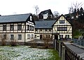
Building complex

Above ground building of the Molchner tunnel
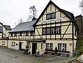
Huthaus zum Molchner Stolln

Access to the Molchner Spatgang
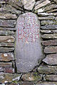
Landmark from 1733
.jpg)

.jpg)
.jpg)

particularities
The Molchner Stolln shows, among other things, the functioning replica of a piece of art and a mining-historical landmark from 1733, which could be deciphered.