
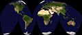
Mollweide projection


The Mollweide is one of a Karl Mollweide developed -area map projection , which represents the entire earth's surface as an ellipse.
Equator and the central meridian (often the zero meridian ) are drawn to scale as a straight line. Circles of latitude are shown as straight lines, meridians as ellipses. The meridian opposite the central meridian forms the outer edge of the map. The meridians, which are offset by ± 90 ° from the central meridian, form a circle. The distortion increases sharply with increasing distance from the equator and central meridian.
The similar looking Hammer-Aitov projection has lower angular distortions and is therefore more vivid, but it is more complex to calculate. On the other hand, it has no parallel parallel parallels, which is unfavorable for zone models, for example. Therefore, the Mollweide projection is particularly popular for climatological, biological and similar thematic maps.
There is a ragged, surface and position true form according to JP Goode , the Goode-Homolosine-Projection .
Homolosine (Goode zapping) , true to
area and position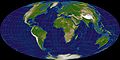
Hammer-Aitov ,
true to area


Web links
- Eric W. Weisstein : Mollweide Projection . In: MathWorld (English).