
Monserrate (Colombia)
| Cerro de Monserrate | ||
|---|---|---|
 |
||
| height | 3152 m | |
| location | Colombia , Bogotá | |
| Mountains | To the | |
| Coordinates | 4 ° 36 '20 " N , 74 ° 3' 20" W | |
|
||


The Cerro de Monserrate is a 3,152 meter high mountain in the Santa Fe district of the Colombian capital Bogotá . Its peak rises on the southeastern edge of the city. Together with the Cerro de Guadalupe (3317 meters), which is about 1,600 meters to the south, it shapes the panorama of the capital and is visible from almost everywhere, making it the trademark of Bogotá. The Monserrate is located in the Enrique Olaya Herrera National Park .
The picturesque, whitewashed basilica of the Lord of Monserrate was built on the Monserrate in the 17th century and is a popular pilgrimage site with the shrine of the "Fallen Jesus" ( El Señor Caído ). The Christ statue in the shrine was also made in the 17th century by Pedro de Lugo Albarracín . The church and mountain were named after the Montserrat Mountains near Barcelona in Spain .
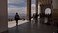
On the Monserrate perform a funicular , which leads some distance by a tunnel, and a pendulum cable car . It can also be reached via a marked hiking trail through the forest, which leads over a length of 2,240 meters from 2,693 to 3,160 meters. Various tourist facilities with a viewing platform from which visitors have a wide view over the savannah of Bogotá , restaurants and cafes are located on the summit.

Funicular valley station

View of Bogotá
View from the Basílica Santuario del Señor de Monserrate

Jesus on the cross

Jesus after the crucifixion
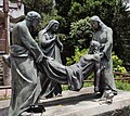
Lament over Jesus' death

View of the Cerro de Guadalupe

Funicular railway - entry into the tunnel


Web links
- Explanatory website on how to get to the Monserrate (Spanish)
- Homepage of the shrine on the Monserrate (Spanish)
- Pilgrim mountain in Colombia: scrambling on Good Friday , article by Tobias Buyer in Spiegel Online , April 6, 2012
Individual evidence
- ↑ Parque Nacional Enrique Olaya Herrera idrd.gov.co, accessed on May 26, 2019 (Spanish)
- ↑ Bogota Travel Guide - The 22 Places To Go in Bogotá: Monserrate. Retrieved January 22, 2011 .
- ↑ PERFIL SENDERO PEATONAL CERRO DE MONSERRATE. In: http://cerrodemonserrate.blogspot.com . Retrieved July 15, 2019 .