
Mont Pilat
| Mont Pilat | ||
|---|---|---|
![Crêt de la Perdrix (with lift supports) [1]](https://de.wikipedia.org/wiki/Datei:Jasserie1308-2.jpg) Crêt de la Perdrix (with lift supports) |
||
| Highest peak | Crêt de la Perdrix ( 1432 m ) | |
| location | Loire department , France | |
| part of | Massif Central | |
|
||
| Coordinates | 45 ° 23 ' N , 4 ° 34' E | |

Mont Pilat (German "Pilatus Mountain" ) is the name of a massif in the French department of Loire on the eastern edge of the Massif Central . It is located east of Saint-Étienne and is bounded by Greed to the northwest and the Rhone to the east. It covers approx. 700 km², its highest point is the Crêt de la Perdrix at 1,432 meters .
The Mont Pilat has a very species-rich flora, which is mainly due to the fact that in its west there is the continental mountain climate of the Central Massif, while the climate towards the Rhone Valley takes on a Mediterranean character.
At the Crêt de la Perdrix are the remains of one of the oldest surface lifts in France (built around 1929). On the 1362 meter high Crêt de l'Œillon there is a transmission mast for French television. At the Col de la République , via which the N82 has opened up Mont Pilat since 1832, a Christian sect lived during the French Revolution, which was later violently dissolved.
In 1974 the Pilat Regional Nature Park ( French Parc naturel régional du Pilat ) was founded.

Location of Mont Pilat on a road map
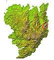
Location of Mont Pilat within the Massif Central


Web links
- Parc naturel régional du Pilat (Pilat Regional Nature Park). Retrieved December 5, 2010 (French / German / English).
Individual evidence
- ↑ a b Laurent Berne: TK de la Jasserie du Pilat. September 21, 2009, accessed December 5, 2010 (French, many historical images).
- ↑ Gérard Aventurier: Histoire du Jansénisme en Forez ... In: La troisième phase du jansénisme: le jansénisme convulsionnaire. Amis du Vieux Saint-Etienne, June 13, 2004, accessed December 5, 2010 (French).