
Pilat Regional Nature Park


.JPG)

The Pilat Regional Nature Park ( French Parc naturel régional du Pilat ) is located in the French region of Auvergne-Rhône-Alpes and includes parts of the Loire and Rhône departments . It stretches roughly southwest of Lyon , is bordered by the Rhône river to the east and by its tributary Gier to the west, and meets the Haute-Loire department in the south . In the center is the eponymous mountain range Mont Pilat .
Park management
The nature park was founded on May 17, 1974 and today covers an area of around 70,000 hectares. The park administration is based in Pélussin ( 45 ° 25 ′ 9 ″ N , 4 ° 40 ′ 12 ″ E ), where the "Maison du Parc" is located is located. 47 municipalities with a catchment area of around 50,000 inhabitants form the park, and 16 outlying municipalities are associated with the park as access points.
The main access points
- Annonay
- Firminy
- Givors
- La Grand-Croix
- Rive-de-greed
- Saint-Chamond
- Saint-Étienne and some other municipalities in the metropolitan area
Larger places in the park
- Ampuis
- Bourg-Argental
- Chavanay
- Condrieu
- Loire-sur-Rhône
- Pélussin
- Saint-Paul-en-Jarez
- Saint-Genest-Malifaux

Landscapes
The nature park lies on the border of two climatic zones . While the continental climate of the Massif Central predominates in the west, the Mediterranean character already dominates in the east, especially in the Rhone Valley . In addition, there is also an alpine mountain climate in the summit zone of Pilat . Due to its structure, the area can be divided into the following landscapes:
- Piémont Rhodania
The area is in the east of the nature park. Here the Rhône follows the boundary of the park of Givors in the north to the municipality of Saint-Pierre-de-Bœuf . Along the river and on the agriculturally used plateau at approx. 400 meters above the valley, various paths cross the Piémont Rhodania under the protection of the last wooded foothills of the Massif Central. Here the farmers have specialized: they cultivate crops , keep animals or have become winegrowers . In the north, dairy cows and goats graze in the meadows . The “Rigotte de Condrieu”, a local goat cheese , has become a trademark here. In the south of the area, fruit growing has specialized in the production of apples . The high altitude and the light, sandy soils allow particularly tasty apples to ripen. Grapevines thrive on the terraces of the steep slopes that dominate the Rhône Valley. The cultivation of the vineyards is extremely difficult because it cannot be mechanized. Despite this, the wine culture is quite profitable thanks to the excellent quality of the wines produced.

Vineyards in Ampuis

Goat cheese from Condrieu

View from Malleval into the Rhône Valley

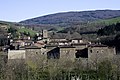
Saint Appolinard

Saint-Pierre-de-Boeuf on the Rhône
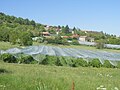
Apple orchards in Véranne


.JPG)
.jpg)

.JPG)
- Vallée de la Déôme
The valley of the river Déome , which bears the name Deume in the lower reaches , lies in the southwest of the nature park. The deeply cut river forms the southern border of the Pilat and separates it from the Boutières mountain range further south . Large fir and beech forests cover the heights and slopes to the north, while meadows and hardwood alternate on the sunlit southern slopes and in the valley basins. From the 18th century onwards, the rivers made it possible to build textile factories that used the driving force of water. Today the industrial architecture of that time represents a special cultural heritage, such as B. in the places Bourg-Argental and Saint-Julien-Molin-Molette .

View over Bourg-Argental to the south
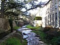
Saint-Julien-Molin-Molette on the Ternay tributary

.jpg)
- Skin pilat
The area extends in the south of the nature park and lies on a granite block around 1000 meters high, which is covered by moist, sometimes peaty meadows. Rivers such as the Semène and Dunières, which drain to the Loire, arise from numerous sources .
The main focus in the management of this area is dairy farming . In summer the cows are kept on the pasture , in winter the animals are fed in the barn from the hay harvest . The most common breed of cow is the Montbéliards , a brown and white spotted species that originally comes from the Jura and withstands the harsh climate well. Alternatively, the black and white spotted cows of the Holstein breed are kept, which give more milk but are less resilient.

View of Saint-Régis-du-Coin

Moor meadow near Saint-Régis-du-Coin

Natural landscape near Marlhes

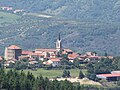
Saint-Genest-Malifaux

Montbeliard cows

The Semène on the Saint-Genest-Malifaux reservoir


- Les Crêts
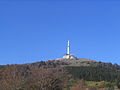
The crêts denote the peaks covered by heather , which culminate in the Crêt de la Perdrix (1432 m) in the heart of the Pilat massif. Other prominent elevations are the Crêt de Botte (1387 m), the Crêt de l'Œillon (1362 m) and Les Trois Dents (1213 m). The harsh climatic conditions, the typical mountain vegetation and the extensive rock scree contribute to the fact that this landscape has all the characteristics of a mountain region. Winter sports can also be practiced here. Surrounded by deep forests, the crêts also offer a unique view of the Alps and the Massif Central.

Scree rocks on the Pilat
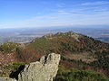
Les Trois Dents

Crêt de la Perdrix
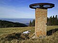
Former ski lift at La Jasserie
Crêt de l'Œillon
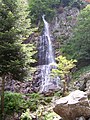
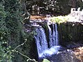
The waterfall Saut du Gier


- Pilat du Giers or Jarez
The area is located in the northwest of the nature park and is based on the river Gier , which has its source in the Crêts, leaves the nature park after about ten kilometers at Saint-Chamond , but then strives to the northeast and runs just outside the nature park to its northern end and there flows into the Rhône. The rivers Dorlay and Couzon also belong to its catchment area . From east to west, the landscape first shows open landscapes with heathland or pastureland , then deep gorges follow , in which the rivers have sometimes been turned into reservoirs . Conifer forests cover the hilly and rocky reliefs. Like the Haut-Pilat area , the Jarez , whose slopes lead to the industrialized Valley of Greed, is a land of cattle breeding . The farmers sell their products in the nearby cities, but are often only part-time farmers and also have other jobs in the city.
Le Bessat
Farnay
Charterhouse of Sainte-Croix-en-Jarez

Stable in Dizimieux, Longes municipality
Greed at Saint-Chamond
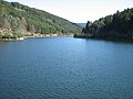
Pas-du-Riot reservoir on the Furan River


See also
Web links
- Website of the nature park (German)