Montague (Prince Edward Island)
| Montague | ||
|---|---|---|
| Nickname : Montague The Beautiful | ||
| Location in Prince Edward Island | ||
|
|
||
| State : |
|
|
| Province : | Prince Edward Island | |
| County: | Kings County (Prince Edward Island) | |
| Coordinates : | 46 ° 10 ′ N , 62 ° 39 ′ W | |
| Area : | 3.04 km² | |
| Residents : | 1802 (as of 2006) | |
| Population density : | 592.8 inhabitants / km² | |
| Time zone : | Atlantic Time ( UTC − 4 ) | |
| Postal code : | 1RO | |
| Area code : | +1 902 | |
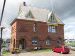
 Garden of the Gulf Museum |
||
Montague is a city in Kings County in the Canadian province of Prince Edward Island .
geography
Montague is located approximately 45 kilometers east of Charlottetown and 15 kilometers west of Georgetown on Prince Edward Island Route 4 .
history
The first inhabitants in the area of today's city were the Paleo-Indians and later the Mi'kmaq- Indians . In 1731 the first French settlers from Cape Breton in the province of Nova Scotia came to the area, and Jean-Pierre Roma named the location "Three Rivers" because of three rivers that flow together there, now called Montague River , Brudenell River and Cardigan River . In the 1820s over 800 settlers, mainly from Scotland , came to the Three Rivers area. When a bridge was built over the rivers a few years later, the city continued to grow. The Montague River was named in honor of either George Brudenell, 4th Earl of Cardigan (later George Montagu, 1st Duke of Montagu ), or John Montagu, 4th Earl of Sandwich or Montague Wilmot , the first governor of Nova Scotia. Because of the idyllic location with the river flowing calmly through the city, the tree-lined streets and the stately houses, Montague likes to call itself today: "Montague The Beautiful".
Demographics
In 2006 there was a population of 1802 people. The average age at this point was 45.4 years.
