Charlottetown
| Charlottetown | ||
|---|---|---|
 |
||
 coat of arms |
 flag |
|
| Motto : Cunabula Foederis (Cradle of the Confederation) | ||
| Location in Prince Edward Island | ||
|
|
||
| State : |
|
|
| Province : | Prince Edward Island | |
| County: | Queens County | |
| Coordinates : | 46 ° 14 ′ N , 63 ° 8 ′ W | |
| Height : | 10 m | |
| Area : | 44.33 km² | |
|
Inhabitants : - Metropolitan Area : |
34,562 (as of 2011) 64,487 (as of 2011) |
|
| Population density : | 779.7 inhabitants / km² | |
| Time zone : | Atlantic Time ( UTC − 4 ) | |
| Postal code : | C1A - C1E | |
| Foundation : | 1764 | |
| Mayor : | Clifford J. Lee | |
| Website : | www.city.charlottetown.pe.ca | |
Charlottetown [ ˈʃɑːrləttaʊn ] is a city in Canada and the capital of the province of Prince Edward Island . It is located in Queens County and has a population of around 35,000. Charlottetown was founded in 1764 and named after the then British Queen Sophie Charlotte von Mecklenburg-Strelitz .
geography
Charlottetown is located on Charlottetown Harbor, a natural harbor formed by the confluence of the three rivers Hillsborough, Yorke and Eliot. The port is connected to the Northumberland Strait by a strait two kilometers long and 500 m wide . The city is located on a south-tapering peninsula bounded to the west by the Yorke River and to the east by the Hillsborough River.
history
The area around Charlottetown was originally settled by the Mi'kmaq . The first European settlers were French soldiers from Louisbourg , who in 1720 built the fortress Port-la-Joye in the south-western part of the port, opposite today's city center . During the French and Indian War, British troops captured the small settlement and the rest of the island in August 1758. The British deported the French settlers and built Fort Amherst on the site of the abandoned settlement.
The surveyor Samuel Holland chose the area as the location of the district authorities of the future Queens County . A year later, the settlement named after Sophie Charlotte von Mecklenburg-Strelitz became the capital of what was then still known as St. John's Island . Further measurements from 1768–1771 determined the street layout and the location of the public spaces. On November 17, 1775, during the American Revolutionary War , American privateers looted the city and took several hostages, which they later released.
In 1805 the British garrison built a fortress called Fort Edward in the western part of the port. In 1835 the Government House was built as the governor's seat; today the lieutenant governor resides here . Between 1845 and 1847 the parliament building, the Province House, was built. On April 17, 1855, Charlottetown, which then had a population of around 6,500, was declared an independent municipality from the rest of the district.
From September 1 to 8, 1864, the Charlottetown Conference took place here, at which the future Canadian Confederation was discussed. After Charlottetown became a provincial capital on July 1, 1873 when the island joined Canada, it received city rights in 1885.
In 1938 the Royal Canadian Air Force opened an air base , which was converted into Charlottetown Airport in 1946 . Numerous warships were repaired and maintained in the city's shipyards during World War II .
In 1969, the University of Prince Edward Island was created through the merger of two existing universities . The Canadian Department of Veterans Affairs ( Veterans Affairs Canada ) moved its headquarters to Charlottetown in 1983 as part of a decentralization program. After the Canadian National Railway shut down all of the island's railway lines in 1989, the disused railway systems were put to new uses. In 1995, Charlottetown merged with the suburbs of Sherwood, Parkdale, Winsloe, West Royalty and East Royalty.
climate
|
Average monthly temperatures and rainfall for Charlottetown
|
|||||||||||||||||||||||||||||||||||||||||||||||||||||||||||||||||||||||||||||||||||||||||||||||||||||||||||||||||||||||||||||||||||||||||||||||||||||||||||||||||||||||||||||||||||||||||||||||||||||||||||||||||||||||||||||||||
economy
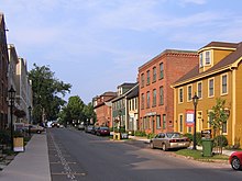
Charlottetown's economy is dominated by state administration. Provincial, federal, and city authorities are major employers, as are the health and education sectors. The main industries are the food industry and the manufacture of wood products , steel goods and woolen goods . Even the tourism for the city of importance, due to numerous watchable 19th century.
Education and culture
Charlottetown is home to the University of Prince Edward Island , the Province House built in 1847, the Government House and the Confederation Center of the Arts museum . Charlottetown has two cathedrals, the Roman Catholic Cathedral Basilica of St. Dunstan and the Anglican St. Peter's Cathedral. The annual Charlottetown Festival is the island's biggest tourist attraction. The best-known sports team are the Charlottetown Islanders , a junior ice hockey team that plays its home games in the Charlottetown Civic Center .
Broadcasting station:
- CFCY-FM , 95.1 MHz
traffic
Due to its central location in the province, the city developed into a transport hub. Important road connections were completed at the end of the 20th century. These include the Trans-Canada Highway , which also connects the northern suburbs with Riverside Drive, the Hillsborough River Bridge, the North River Causeway / Bridge and the Confederation Bridge in the west and the Northumberland Ferry Terminal in the east. Route 2 is the main highway from east to west and serves as a feeder to the Trans-Canada Highway.
Charlottetown Airport is the only airport in the province with scheduled flights. The airport counts 280,000 passengers annually. It is also the hub of Prince Edward Air . The municipal company T3 Transit is the regional provider of local public transport. The company operates ten routes in the city.
Personalities
- Louis Henry Davies (1845–1924), judge and politician
- Robert Ghiz (* 1974), politician
- Ron Hastings (1936-2006), stage actor
- Ross Johnston (born 1994), ice hockey player
- Al MacAdam (* 1952), ice hockey player
- Drew MacIntyre (born 1983), ice hockey goalkeeper
- Martha MacIsaac (* 1984), actress
- Bob MacMillan (born 1952), ice hockey player
- Logan MacMillan (born 1989), ice hockey player
- Walter MacNutt (1910–1996), organist, composer, choir director and music teacher
- Dave Cameron (born 1958), ice hockey player and coach
- James Andrew Joseph McKenna (1862-1919), lawyer and chief inspector of Indian agencies in Manitoba and the Northwest Territories
- Bob Stewart (1950-2017), ice hockey player
- Paul Thompson (born 1940), theater director


