Prince Edward Island Route 4
| Route 4 in Prince Edward Island, Canada | |||||||||||||||||||||||||||||||||||||||||||||||||
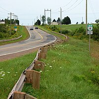
| The Seven Mile Road | |||||||||||||||||||||||||||||||||||||||||||||||||

|
|||||||||||||||||||||||||||||||||||||||||||||||||
| Basic data | |||||||||||||||||||||||||||||||||||||||||||||||||
| Operator: | Transportation and Infrastructure Renewal Prince Edward Island |
||||||||||||||||||||||||||||||||||||||||||||||||
| Start of the street: |
Wood Islands ( 45 ° 58 ′ N , 62 ° 45 ′ W ) |
||||||||||||||||||||||||||||||||||||||||||||||||
| End of street: |
Dingwells Mills ( 46 ° 22 ′ N , 62 ° 27 ′ W ) |
||||||||||||||||||||||||||||||||||||||||||||||||
| Overall length: | 63 km | ||||||||||||||||||||||||||||||||||||||||||||||||
|
County : |
|||||||||||||||||||||||||||||||||||||||||||||||||
| Route 4 at Cardigan | |||||||||||||||||||||||||||||||||||||||||||||||||
|
Course of the road
|
|||||||||||||||||||||||||||||||||||||||||||||||||
The Route 4 of the Canadian province of Prince Edward Iceland is located in the east of the island. It has a total length of 63 km. It begins in Wood Island on Route 1 , the Trans-Canada Highway , right at the ferry terminal to Nova Scotia . The route heads west along the coast, then swings north to the Murray River . The highway runs through Montague and past Cardigan and ends at Route 2 . North of Montague, east of the route, is the Brudenell River Provincial Park .
Individual evidence
- ^ Roads Act Highway Access Regulations. (PDF; 603 kB) 2011, accessed on May 21, 2012 (English).
