Prince Edward Island Route 1
| Route 1 in Prince Edward Island, Canada | |||||||||||||||||||||||||||||||||||||||||||||||||||||||||||||||||||||||||||||||||||||||||||||||||||||||
| Trans-Canada Highway (English) Route Transcanadienne (French) |
|||||||||||||||||||||||||||||||||||||||||||||||||||||||||||||||||||||||||||||||||||||||||||||||||||||||

|
|||||||||||||||||||||||||||||||||||||||||||||||||||||||||||||||||||||||||||||||||||||||||||||||||||||||
| Basic data | |||||||||||||||||||||||||||||||||||||||||||||||||||||||||||||||||||||||||||||||||||||||||||||||||||||||
| Operator: | Transportation and Infrastructure Renewal Prince Edward Island |
||||||||||||||||||||||||||||||||||||||||||||||||||||||||||||||||||||||||||||||||||||||||||||||||||||||
| Start of the street: |
Confederation Bridge ( 46 ° 13 ′ N , 63 ° 44 ′ W ) |
||||||||||||||||||||||||||||||||||||||||||||||||||||||||||||||||||||||||||||||||||||||||||||||||||||||
| End of street: |
Wood Islands ( 45 ° 57 ′ N , 63 ° 44 ′ W ) |
||||||||||||||||||||||||||||||||||||||||||||||||||||||||||||||||||||||||||||||||||||||||||||||||||||||
| Overall length: | 121 km | ||||||||||||||||||||||||||||||||||||||||||||||||||||||||||||||||||||||||||||||||||||||||||||||||||||||
|
County : |
|||||||||||||||||||||||||||||||||||||||||||||||||||||||||||||||||||||||||||||||||||||||||||||||||||||||
| Confederation Bridge | |||||||||||||||||||||||||||||||||||||||||||||||||||||||||||||||||||||||||||||||||||||||||||||||||||||||
|
Course of the road
|
|||||||||||||||||||||||||||||||||||||||||||||||||||||||||||||||||||||||||||||||||||||||||||||||||||||||
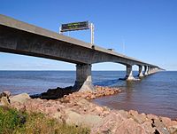
The Prince Edward Iceland Route 1 is part of the Trans-Canada Highway . The highway begins in the middle of the Confederation Bridge on the border with New Brunswick and ends at the Wood Island ferry terminal , from where Caribou in Nova Scotia is called; there the Trans-Canada Highway has its continuation as Nova Scotia Highway 106 .
Route
The Confederation Bridge between mainland Canada and Prince Edward Island marks the beginning of the highway. It is the extension of New Brunswick Route 16 . The route leads ashore in the Port Borden district of Borden-Carleton parish . The highway heads northeast to turn southeast at Albany Corner and open up the coastal communities. The highway leads to the provincial capital, Charlottetown , south past the Charlottetown airport and from there further east. The end is in Wood Island at the ferry terminal there.
Web links
Individual evidence
- ↑ Confederation Bridge. Retrieved March 11, 2012 (English / French).
