Autoroute 40 (Québec)

from Wikipedia, the free encyclopedia
Template: Infobox high-level road / Maintenance / CA / QC-TA
Autoroute 40 in Quebec, Canada
Autoroute Félix-Leclerc
Autoroute Métropolitaine
Autoroute 40 (Québec)Autoroute 40 (Québec)
map
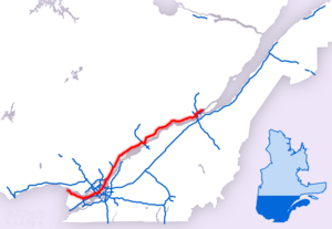
Course of the TA 40
Basic data
Operator: Ministère des transports du Québec
Start of the street: Pointe-Fortune
( 45 ° 32 ′  N , 74 ° 23 ′  W )
End of street: Québec
( 46 ° 53 ′  N , 71 ° 9 ′  W )
Overall length: 341 km

Region :

Autoroute 40 Montreal.JPG
Autoroute 40 in Montréal
Course of the road
Further on T417
===Template: AB / Maintenance / BLD OntarioOntario Ontario
Montérégie
Locality Pointe Fortune
Locality Rigaud
Locality Saint-Lazare
Locality Vaudreuil-Dorion
node A540S to Salaberry-de-Valleyfield
flow Lac des Deux-Montagnes (Pont de l'Île aux Tourtes)
Montréal
Locality Senneville
Locality Sainte-Anne-de-Bellevue
Locality Kirkland
Locality Pointe Claire
Locality Montréal
node A13N to Boisbriand , S to Montréal -Lachine
node A520W after Dorval
node A15S to Saint-Bernard-de-Lacolle , R117N to Rouyn-Noranda
node A15N to Sainte-Agathe-des-Monts
node A19N to Laval
node A25N to Saint-Esprit , S to Longueuil
flow Rivière des Prairies (Pont Charles-De Gaulle)
Lanaudière
Locality Terrebonne
node A640W to Laval , O to Charlemagne
Locality Charlemagne
Locality Repentigny
Locality L'Assomption
Locality Lavaltrie
node A31W to Joliette , R131O to Lavaltrie
Locality Lanoraie
Locality Sainte-Geneviève-de-Berthier
Locality Berthierville
node R158W to Lachute , O to Berthierville
node R138W to Huntingdon , O to Trois-Rivières
Locality Saint-Cuthbert
Locality Saint Barthelemy
Mauricie
Locality Maskinongé
Locality Louiseville
Locality Yamachiche
node R153N to Lac-aux-Sables
Locality Trois-Rivières
node A55N to Shawinigan
node A55S to Stanstead
flow Rivière Saint-Maurice (Pont Radisson)
node R157S to Trois-Rivières , N to Shawinigan
Locality Saint-Maurice
Locality Champlain
Locality Sainte-Geneviève-de-Batiscan
Locality Sainte-Anne-de-la-Pérade
node R159S to Sainte-Anne-de-la-Pérade , N to Saint-Roch-de-Mékinac
Capitale-Nationale
Locality Deschambault-Grondines
Locality Portneuf
Locality Cap Santé
Locality Donnacona
Locality Neuville
Locality Saint-Augustin-de-Desmaures
node R138W to Trois-Rivières , O to Natashquan
Locality Quebec
node A540S to Québec -St. Louis
node A73S to Beauceville -St. Louis, A440N to Québec -Centre Ville
node A573N to Saint-Gabriel-de-Valcartier
node A73N to Stoneham-et-Tewkesbury , A973S to Québec -Centre Ville
node A440S to Québec -Centre Ville
Further on R138

The Autoroute 40 in the eastern Canadian province of Quebec is one part of the Trans-Canada Highway system. It is the continuation of the Ontario Highway 417 and has a length of 341 km.

Route description

The autoroute begins on the border to the western neighboring province of Ontario and continues on Highway 417 there, making it part of the Trans-Canada Highway. Like all autoroutes in Québec, this one is developed like a motorway. The car route runs south of the Ottawa River to Vaudreuil-Dorion . There, the Autoroute 40 meets the Autoroute 540 , which represents a connection to the Autoroute 20 . The Autoroute 40 leads with the Pont de l'Île aux Tourtes over the Lac des Deux Montagnes and comes to the metropolis of Montréal .

The road runs north of Montréal-Trudeau airport , east of the airport intersects Autoroute 13 . In the Saint-Laurent district, Autoroute 15 meets 40 and runs together for 4 km. In the district of Anjou, Autoroute 25 crosses , which from this section takes on the designation as Trans-Canada Highway heading east. The route is now based on the course of the St. Lawrence River and runs parallel to its northern bank. Autoroute 55 crosses in Trois-Rivières and has a common route for 3.5 km. The car route continues to the northeast and arrives in the provincial capital Québec . This is bypassed in a north-westerly direction, and when you arrive at the St. Lawrence River, the route ends.

Expansion projects

The connection to Montréal-Trudeau Airport is to be modernized and the project is to be completed by 2017.

Web links

Commons : Autoroute 40  - collection of images, videos and audio files

Trans-Canada Highway website

Individual evidence

  1. ^ Transports Québec: Repertoire des autoroutes du Québec. (No longer available online.) Archived from the original on February 26, 2016 ; Retrieved on February 26, 2016 (French). Info: The archive link was inserted automatically and has not yet been checked. Please check the original and archive link according to the instructions and then remove this notice. @1@ 2Template: Webachiv / IABot / www.mtq.gouv.qc.ca
  2. Lancement de l'appel d'offres. (No longer available online.) Gouvernement du Québec, Ministère des Transports, de la Mobilité durable et de l'Électrification des transports, archived from the original on February 26, 2016 ; Retrieved on February 26, 2016 (French). Info: The archive link was inserted automatically and has not yet been checked. Please check the original and archive link according to the instructions and then remove this notice. @1@ 2Template: Webachiv / IABot / www.projetsmajeurs.mtq.gouv.qc.ca