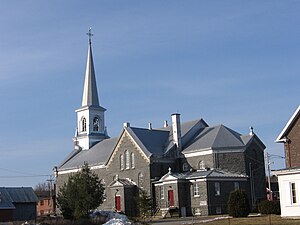
Portneuf (Quebec)
| Portneuf | ||
|---|---|---|
 |
||
| Location in Quebec | ||
|
|
||
| State : |
|
|
| Province : | Quebec | |
| Administrative region : | Capitale-Nationale | |
| MRC or equivalent : | Portneuf | |
| Coordinates : | 46 ° 42 ′ N , 71 ° 53 ′ W | |
| Area : | 110.43 km² | |
| Residents : | 3141 (as of 2006) | |
| Population density : | 28.4 inhabitants / km² | |
| Time zone : | Eastern Time ( UTC − 5 ) | |
| Municipality number: | 34048 | |
| Mayor : | Nelson Bédard | |
| Website : | www.villedeportneuf.com | |
Portneuf is a city ( ville ) in the MRC Portneuf of the same name in the Canadian province of Québec .
The city on the north bank of the St. Lawrence River counted a total of 3141 inhabitants in 2006 and has an area of 110.43 km². In Portneuf the river of the same name, Rivière Portneuf, flows into the St. Lawrence River. The city of Pontneuf is located between Cap-Santé in the east and Deschambault-Grondines in the west.
history
Portneuf was founded in 1636 by Jacques Leneuf de La Poterie.
traffic
Portneuf is 60 km west of the provincial capital Québec . The Trans-Canada Highway runs from Québec to Deschambault-Grondines. Autoroute 40 , which continues to the south, leads to Trois-Rivières .
Portneuf is connected to the VIA Rail Canada rail network.
