
Deschambault-Grondines
| Deschambault-Grondines | |||
|---|---|---|---|
 |
|||
| Location in Quebec | |||
|
|||
| State : |
|
||
| Province : | Quebec | ||
| Administrative region : | Capitale-Nationale | ||
| MRC or equivalent : | Portneuf | ||
| Coordinates : | 46 ° 39 ′ N , 71 ° 56 ′ W | ||
| Area : | 125.59 km² | ||
| Residents : | 2193 (as of 2014) | ||
| Population density : | 17.5 inhabitants / km² | ||
| Time zone : | Eastern Time ( UTC − 5 ) | ||
| Municipality number: | 18050 | ||
| Mayor : | Gaston Arcand | ||
| Website : | www.villededeschambault-grondines.com | ||

Deschambault-Grondines [ deʃɑ̃ˈbo gʁɔ̃ˈdin ] is a municipality ( Municipalité ) in the MRC Portneuf in the Canadian province of Québec .
Deschambault-Grondines is located 60 km west of the provincial capital Québec on the north bank of the Saint Lawrence River . The municipality had a total of 2032 inhabitants in 2006 and has an area of 125.59 km².
history
Deschambault-Grondines was founded in 1640 by the Seigneur de Chavigny. On February 27, 2002, the two communities Deschaumbault and Grondines were merged.
traffic
The Trans-Canada Highway runs from Québec to Deschambault-Grondines. Autoroute 40 , which continues to the south, leads to Trois-Rivières . Deschambault-Grondines is connected to the rail network of VIA Rail Canada .
Sons and daughters of the church
- André Trottier (1901-?), Singer
Web links
Individual evidence


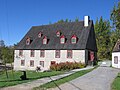
Rectory 1815-1818

Rectory 1815-1818
Mill 1802

Neuville Mill


