Autoroute 73 (Québec)
| Autoroute 73 in Quebec, Canada | ||||||||||||||||||||||||||||||||||||||||||||||||||||||||||||||||||||||||||||
| Autoroute Robert-Cliche Autoroute Henri-IV Autoroute Laurentienne |
||||||||||||||||||||||||||||||||||||||||||||||||||||||||||||||||||||||||||||

|
||||||||||||||||||||||||||||||||||||||||||||||||||||||||||||||||||||||||||||
| map | ||||||||||||||||||||||||||||||||||||||||||||||||||||||||||||||||||||||||||||
| Basic data | ||||||||||||||||||||||||||||||||||||||||||||||||||||||||||||||||||||||||||||
| Operator: | Ministère des transports du Québec | |||||||||||||||||||||||||||||||||||||||||||||||||||||||||||||||||||||||||||
| Start of the street: |
Stoneham-et-Tewkesbury ( 47 ° 6 ′ N , 71 ° 21 ′ W ) |
|||||||||||||||||||||||||||||||||||||||||||||||||||||||||||||||||||||||||||
| End of street: |
Beauceville ( 46 ° 15 ′ N , 70 ° 47 ′ W ) |
|||||||||||||||||||||||||||||||||||||||||||||||||||||||||||||||||||||||||||
| Overall length: | 109.7 km | |||||||||||||||||||||||||||||||||||||||||||||||||||||||||||||||||||||||||||
|
Region : |
||||||||||||||||||||||||||||||||||||||||||||||||||||||||||||||||||||||||||||
| The Pont Pierre-Laporte across the Saint Lawrence River | ||||||||||||||||||||||||||||||||||||||||||||||||||||||||||||||||||||||||||||
|
Course of the road
|
||||||||||||||||||||||||||||||||||||||||||||||||||||||||||||||||||||||||||||
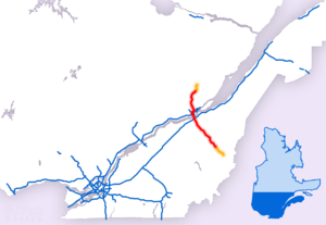
The Autoroute 73 is a highway in the Canadian province of Quebec . It is 109.7 km long and is an important north-south connection in the Capitale-Nationale and Chaudière-Appalaches regions as well as in the provincial capital Québec .
Route description
The northernmost section of the motorway is called Autoroute Laurentienne . It begins in the middle of the Laurentine Mountains in the municipality of Stoneham-et-Tewkesbury , where it is congruent over a length of 30 km with the motorway-like route 175 starting in Saguenay . In the north of the city of Québec it meets the Autoroute 40 , where the Autoroute 973 branches off into the city center. For the next six kilometers, the motorway leads westwards and is congruent with Autoroute 40; this section is also known as the Autoroute Félix-Leclerc .
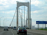
Under the name Autoroute Henri IV , the motorway turns again to the south at the junction with Autoroute 573 . It is still congruent with Autoroute 40 for three kilometers. Autoroute 73 is the most important and busiest north-south connection in the urban area of Québec. The St. Lawrence River is crossed with the Pont Pierre-Laporte , a 1041 meter long suspension bridge .
The section south of the St. Lawrence River, which begins in the urban area of Lévis , is called Autoroute Robert-Cliche . Shortly after the suspension bridge is the motorway junction with Autoroute 20 . Autoroute 73 follows the valley of the Rivière Chaudière towards the Appalachian Mountains , crossing the river three times. The end of the motorway is currently north of the village of Beauceville . To the east of the city of Saint-Georges there is still a five-kilometer section, the traffic value of which is still rather low due to the lack of connection to the rest of the motorway.
history
The motorway was opened in numerous short sections:
- 1963: Autoroute Henri IV between Boulevard Champlain and Autoroute 440 (City of Québec)
- 1963: Autoroute Laurentienne between Autoroute 40 and exit 158 (City of Québec)
- 1968: Autoroute Henri IV between Autoroute 440 and Route 138 (City of Québec)
- 1970: Pont Pierre-Laporte across the Saint Lawrence River between Boulevard Champlain and Lévis
- 1971: Autoroute Henri IV between Route 138 and Autoroute 573 (City of Québec)
- 1977: Autoroute Robert-Cliche between Lévis and Scott
- 1978: Autoroute Robert-Cliche between Scott and Sainte-Marie (Route Cameron)
- 1983: Autoroute Robert-Cliche in Sainte-Marie (between Route Cameron and Route Carter)
- 1989: Autoroute Robert-Cliche between Sainte-Marie (Route Carter) and Vallée-Jonction
- 1992: Robert-Cliche Autoroute between Vallée-Jonction and Saint-Joseph-de-Beauce
- 1994: Autoroute Laurentienne between exit 158 (City of Québec) and Stoneham-et-Tewkesbury
- 2007: Autoroute Robert-Cliche between Saint-Joseph-de-Beauce and Beauceville
- 2013: Autoroute Robert-Cliche in Saint-Georges (between 74e rue and 127e rue)
The section between Beauceville and Saint-Georges is under construction and will be built in two stages. The completion of the Saint-Georges bypass between 127e rue and 204e rue is in the project phase.
Web links
Individual evidence
- ^ Transports Québec: Repertoire des autoroutes du Québec. (No longer available online.) Archived from the original on February 26, 2016 ; Retrieved on February 26, 2016 (French). Info: The archive link was inserted automatically and has not yet been checked. Please check the original and archive link according to the instructions and then remove this notice.
- ^ Repertoire des autoroutes du Québec. (No longer available online.) Transports Québec, archived from the original on February 26, 2016 ; Retrieved on February 26, 2016 (French). Info: The archive link was inserted automatically and has not yet been checked. Please check the original and archive link according to the instructions and then remove this notice.

