Route 132 (Québec)
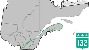
The Route 132 is a state highway ( Route nationale ) of the Canadian province of Quebec , along the southern shore of the St. Lawrence River and along the coast of Gaspésie leads -Halbinsel.
Route description
The 1612.1 km long country road leads from Dundee on the US border 18 km east of Cornwall initially in a northeastern direction along the south bank of the Saint Lawrence River to Salaberry-de-Valleyfield . It continues via Beauharnois and Châteauguay south of Montréal to Sorel-Tracy . Route 132 continues along the southern bank of the Saint Lawrence River via Bécancour to Lévis . The trunk road continues via Montmagny , Rivière-du-Loup and Rimouski to Saint-Flavie . From there it forms a ring road. The southern section of the road leads via Amqui to the provincial border with New Brunswick and further along the south coast of the Gaspésie Peninsula to Gaspé . The northern section of the road runs along the north coast past Matane around the Gaspésie Peninsula to Gaspé, where the ring closes.
Autoroute 30 runs parallel to Route 132 between Salaberry-de-Valleyfield and Sorel-Tracy. In the administrative region of Bas-Saint-Laurent , Autoroute 20 runs parallel to Route 132 from Lévis to Saint-Flavie, with a longer section of Autoroute 20 still running is not realized.
Web links
- Carte routière officielle du Québec
- Ministère des Transports du Québec
- Site officiel des routes touristiques du Québec


