Chateauguay
| Chateauguay | ||
|---|---|---|
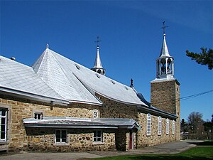
 Saint-Joachim de Chateauguay Church |
||
| Location in Quebec | ||
|
|
||
| State : |
|
|
| Province : | Quebec | |
| Administrative region : | Montérégie | |
| MRC or equivalent : | Roussillon | |
| Coordinates : | 45 ° 22 ′ N , 73 ° 45 ′ W | |
| Height : | 21 m | |
| Area : | 35.89 km² | |
| Residents : | 45,904 (as of 2011) | |
| Population density : | 1,279 inhabitants / km² | |
| Time zone : | Eastern Time ( UTC − 5 ) | |
| Municipality number: | 67050 | |
| Postal code : | J6J, J6K | |
| Area code : | +1 450 | |
| Mayor : | Nathalie Simon | |
| Website : | www.ville.chateauguay.qc.ca | |
 Located in the regional county of Roussillon |
||
Châteauguay is a city in the southwest of the Canadian province of Québec . It is located in the administrative region of Montérégie , a little more than 20 km southwest of Montreal and around 40 km north of the border with the US state of New York . Châteauguay belongs to the regional county municipality (municipalité régionale du comté) Roussillon , has an area of 38.89 km² and has 45,904 inhabitants (2011).
geography
Châteauguay is located in the Rive-Sud region on both sides of the Rivière Châteauguay , a tributary of the Saint Lawrence River . On the northern outskirts of the city, the river divides into two estuary arms that flow into Lac Saint-Louis . The Île Saint-Bernard lies between the two arms of the estuary. Despite its proximity to the city, the lakeshore area is not built over and has extensive wetlands. Neighboring communities are Léry in the west, Sainte-Martine in the southwest, Mercier in the south, Saint-Isidore in the southeast and the Indian reservation Kahnawake in the east.
history
French rule
On September 29, 1673, the governor of New France de Frontenac enfeoffed the Seigneur of Longueuil Charles Lemoyne with the area around the later Châteauguay to make it a seigneury . In 1683 he had a fortified house known as le Chasteau built on the Île Saint-Bernard, and a windmill followed in 1688 . Two families and six other people lived there. The name Châteauguay was taken from the place of the same name in today's French department of Puy-de-Dôme . In 1685 the fighting with the British became so violent that the residents withdrew to the hinterland.
The first landlord was followed in 1706 by Zacharie Robutel de La Noue. His family held the manor until the British conquest. In 1765 it passed to Marguerite d'Youville from the Sœurs de la Charité de Montréal . Marguerite, who came from a wealthy family, used a considerable part of her property to purchase the area. The proceeds were mainly used to care for the approximately 150 poor, for whom the sisters felt responsible. It emerged from Marguerite's notes that the local Indians still made claims on the island, which they qualified as “injustes” (unjustified).
In 1725 there was still only one permanent settlement in the Seigneurie Châteauguay, namely Châteauguay itself, with 15 houses. Montreal consisted of 701 houses at the time. Overall, the Montreal region played a central role in recruiting the voyageurs who carried out the fur trade . About half of these men came from the Île de Montréal , another 30% from the area around Trois-Rivières , the rest from Varennes and Châteauguay.
British rule
Even during the British colonial rule from 1760 and 1763, Châteauguay remained an important center of local power. Over the next few years, the Montreal sisters built a bakery and encouraged the export of locally produced food to Montreal and the south. Construction of the Saint-Joachim church began in 1775, and a permanent pastor's position was occupied from 1777. In 1813 the place became an outpost of the British Army in the war against the USA . On October 26, 1813, the battle of Châteauguay took place. Colonel Charles-Michel de Salaberry and his 300 men managed to arrest the Americans who had invaded. Nevertheless, even after the war, the region remained characterized by the tensions between the two states caused by the proximity of the border.
Nevertheless, there were serious deficiencies in the regional organization for decades. A commission complained in 1826 that there was not even a judge in Châteauguay. During the rebellions of 1837 , British troops occupied the city and deported several insurgents to Australia . In November 1838, as in several other places, there were revolts against the seigneurie. In 1854 the seigneurie was lifted and the municipality elected its first mayor. The export of agricultural products like butter and cheese, especially to the nearby United States, became an important livelihood.
Further development
Even after the founding of the Canadian state in 1867, the place lived largely from agriculture. But around 1900 the deforestation of the area began to meet the wood needs of the metropolises. The present city emerged from the merger with Châteauguay-Heights in 1968 and the incorporation of Châteauguay-Center in 1975. In 1997, the city acquired the oldest residential building in the Monterégie region, the Maison LePailleur from 1792. The Société du, founded in 1989, is there Musée du Grand Châteauguay resident since 1998.
Attractions
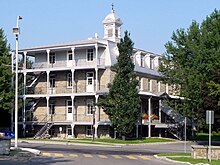
There are two National Historic Sites in Châteauguay : the battlefield of the Battle of Châteauguay is marked by a plaque, the Saint-Joachim church, built between 1774 and 1797, is a well-known example of neo-baroque architecture in the Saint Lawrence Valley. Further sights are the former monastery of the Sœurs de la Charité with adjoining church district, the Maison LePailleur built in 1792 and the Île-Saint-Bernard windmill .
population
According to the 2011 census, Châteauguay had 45,904 inhabitants, which corresponds to a population density of 1279 inhabitants / km². 60.0% of the population stated French as their main language, the share of English was 26.8%. 1.7% said they were bilingual (French and English); 11.5% (including 2.3% Spanish ) accounted for other languages and multiple answers . Only French spoke 29.7%, only English 12.2%. In 2001, 78.0% of the population were Roman Catholic , 13.7% Protestant and 5.6% non-denominational.
traffic
Autoroute 30 runs along the southern outskirts of the city . This highway begins in Vaudreuil-Dorion , bypasses the Montreal metropolitan area extensively and ends in Sorel-Tracy . Route 132 , which follows the southern bank of the St. Lawrence River, is an important national main road . Route 138 branches off from here. The railway line running through the city is currently only used for freight traffic. Several bus routes operated by the CIT du Sud-Ouest company open up the city and connect it with Montreal.
Twin cities
There are city partnerships with Cambrai and Châteaugay in France and with Moose Jaw in the Canadian province of Saskatchewan .
Personalities
- Kim St-Pierre (* 1978), ice hockey player
- Martin Gilbert (* 1982), racing cyclist
- Corey Crawford (born 1984), ice hockey player
- Rick Genest (1985–2018), model and performance artist
Web links
- Official website of Châteauguay (French)
Remarks
- ↑ Châteauguay. Commission de toponymie du Québec, accessed January 29, 2014 (French).
- ↑ Etienne-Michel Faillon: Mémoires particuliers pour sevir à l'histoire de l'Eglise de l'Amerique du Nord , p. 232.
- ↑ Etienne Michel Faillon: Vie de Mme d'Youville, fondatrice des Sœurs de la charité de Villemarie, dans l'île de Montréal, en Canada , Montreal 1852, p. XXV.
- ↑ Alain Laberge, Lina Gouger, Jacques Mathieu: Portraits de Camp Agnes. La Formation du Monde Rural Laurentien au XVIIIe siècle, Presses Université Laval, 2010, p. 113.
- ↑ Carolyn Podruchny: Making the voyageur world: travelers and traders in the North American fur trade , University of Nebraska Press 2006, p. 312, note 48.
- ^ Donald Fyson: Magistrates, Police and People. Everyday Criminal Justice in Quebec and Lower Canada, University of Toronto Press, 2006, p. 58.
- ^ John-A Dickinson, Brian Young: Brève histoire socio-économique du Québec, Sillery: Les éditions du Septentrion, 2003, p. 145.
- ^ John-A Dickinson, Brian Young: Brève histoire socio-économique du Québec, Sillery: Les éditions du Septentrion, 2003, p. 214.
- ↑ Population profile of the municipality of Châteauguay. In: 2011 Census. Statistics Canada , 2011, accessed January 29, 2014 (French).
- ↑ Population profile of the municipality of Châteauguay. In: 2001 Census. Statistics Canada , 2001, accessed January 29, 2014 (French).
- ↑ Villes jumelées. City of Châteauguay, accessed January 29, 2014 (French).


