
Vaudreuil-Dorion
| Vaudreuil-Dorion | |||
|---|---|---|---|
| Location in Quebec | |||
|
|||
| State : |
|
||
| Province : | Quebec | ||
| Administrative region : | Montérégie | ||
| MRC or equivalent : | Vaudreuil-Soulanges | ||
| Coordinates : | 45 ° 24 ′ N , 74 ° 2 ′ W | ||
| Height : | 20 m | ||
| Area : | 72.52 km² | ||
| Residents : | 33,305 (as of 2011) | ||
| Population density : | 459.3 inhabitants / km² | ||
| Time zone : | Eastern Time ( UTC − 5 ) | ||
| Municipality number: | 71083 | ||
| Postal code : | J7T-J7V | ||
| Area code : | +1 450 | ||
| Mayor : | Guy Pilon | ||
| Website : | www.ville.vaudreuil-dorion.qc.ca | ||
 Location in the MRC Vaudreuil-Soulanges |
|||

Vaudreuil-Dorion is a city in the southwest of the Canadian province of Québec . It is located in the Montérégie region , about 40 kilometers west of central Montreal . Vaudreuil-Dorion is the administrative seat of the regional county municipality (municipalité régionale du comté) Vaudreuil-Soulanges , has an area of 72.52 km² and has 33,305 inhabitants (2011). The city was created in 1994 from the merger of the municipalities of Vaudreuil and Dorion.
geography
Vaudreuil-Dorion is located on the south bank of Lac des Deux Montagnes , at the mouth of the Ottawa River in the Saint Lawrence River . To the east of the lake are the islands of Île de Montréal and Île Perrot , which belong to the Hochelaga archipelago . The city consists of two non-contiguous areas; the larger part on the lakeshore with the settlements of Vaudreuil and Dorion and the rural exclave Hudson Acres to the west . The urban area also includes dozens of small islands in the Baie de Vaudreuil; the three largest of them form the protected area Réserve écologique des Îles-Avelle-Wight-et-Hiam .
Neighboring municipalities are Vaudreuil-sur-le-Lac in the north, L'Île-Perrot , Terrasse-Vaudreuil and Pincourt (all on the Île Perrot) in the east, Pointe-des-Cascades and Les Cèdres in the south, Saint-Lazare in the west as well Hudson in the northwest. The Hudson Acres exclave also borders Rigaud .
history
At the end of the 17th century, the entire region west of the Île de Montréal was an important area for the fur trade . On November 23, 1702, the Governor of New France , Hector de Callière , signed two seigneuries west of the Ottawa River. One came into the possession of Philippe de Rigaud de Vaudreuil , the then governor of Montreal , the other went to his brother-in-law Joybert de Soulanges. The place Vaudreuil grew slowly due to its remote location. The Saint-Michel de Vaudreuil church was built between 1783 and 1789.
In 1845 the municipality of Vaudreuil was founded. When the Grand Trunk Railway opened in 1853, the village of Dorion developed at the station, named after the politician Antoine-Aimé Dorion . The place became an independent municipality in 1891. Another growth spurt came with the opening of the freeways from Montreal to Toronto and Ottawa . In 1963 Vaudreuil received city status. On March 16, 1994, Vaudreuil and Dorion merged to form the city of Vaudreuil-Dorion. Since 2000 she has been a member of the communauté métropolitaine de Montréal .
population
According to the 2011 census, Vaudreuil-Dorion had 33,305 inhabitants, which corresponds to a population density of 459.3 inh / km². 64.2% of the population stated French as their main language, the share of English was 19.6%. 1.8% said they were bilingual (French and English), other languages and multiple answers accounted for 14.4%. Only French spoke 27.3%. In 2001, 86.2% of the population were Roman Catholic , 6.2% Protestant and 6.3% non-denominational.
traffic
Vaudreuil-Dorion is a major hub for Canadian rail transport. At the Dorion station, the railway line coming from Montreal branches off towards Ottawa and Toronto. The transport company Agence métropolitaine de transport operates a suburban railway line that runs from Lucien-L'Allier station in Montreal via Dorion and Vaudreuil to Hudson . Several bus routes operated by CIT La Presqu'Île are responsible for fine-tuning the city .
The city is affected by three motorways. In the north, crossing Route 40 on the Pont de l'Ile-aux-Tourtes the Lake of Two Mountains and is on the border with the province of Ontario in the Highway 417 over to Ottawa. In the south, the Autoroute 20 runs towards Toronto, which crosses the Ottawa River on the Pont Taschereau , becomes a short section of the urban area to a non-directional city street and merges into Highway 401 at the provincial border . These two highways are connected by Autoroute 30 (formerly Autoroute 540), which has been crossing the St. Lawrence River since 2012.
photos
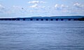
Pont de l'Île aux Tourtes across the lake
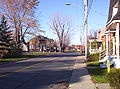
Avenue Saint-Jean-Baptiste in Dorion

Old courthouse


Web links
- Official website of Vaudreuil-Dorion (French)
Individual evidence
- ^ A b Vaudreuil-Dorion , Commission de toponymie du Québec
- ^ Population profile of the municipality of Vaudreuil-Dorion. In: 2011 Census. Statistics Canada , 2011, accessed December 12, 2013 (French).
- ^ Population profile of the municipality of Vaudreuil-Dorion. In: 2001 Census. Statistics Canada , 2001, accessed December 12, 2013 (French).