Hochelaga archipelago
| Hochelaga archipelago | ||
|---|---|---|
| Map of the Hochelaga archipelago | ||
| Waters | Saint Lawrence River | |
| Geographical location | 45 ° 31 ′ N , 73 ° 38 ′ W | |
|
|
||
| Number of islands | 234 | |
| Main island | Île de Montréal | |
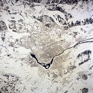
| Winter satellite photo of the Hochelaga archipelago and the Montréal metropolitan area | ||
The Hochelaga Archipelago ( French Archipel d'Hochelaga ) is a group of islands in the southwest of the Canadian province of Québec . It consists of 234 islands at the mouth of the Ottawa in the Saint Lawrence River . The archipelago includes all the islands in the Rivière des Mille Îles and Rivière des Prairies , in the Lac Saint-Louis and Lac des Deux Montagnes and in part of the Saint Lawrence River.
The name is derived from Hochelaga , a village of the Saint Lawrence Iroquois in the 16th century. It was used for the first time in 1935 by Marie-Victorin , a botanist and Catholic friar, who described the flora of the St. Lawrence Valley in the work Flore Laurentienne .
The largest island in the archipelago is the Île de Montréal , on which the city of Montreal is located. The urban area also includes 74 smaller islands, including Île Bizard , Île des Sœurs , Île Notre-Dame , Île Sainte-Hélène and Île de la Visitation . The second largest island in the archipelago is Île Jésus , which together with Îles Laval and other islands form the city of Laval . Other well-known islands are the Îles de Boucherville , Île Dorval , Île Perrot and Île Sainte-Thérèse .
Individual evidence
- ^ Archipelago d'Hochelaga. Commission de toponymie Québec, June 28, 2011, accessed August 27, 2011 (French).


