Route 185 (Québec)
| Route 185 in Quebec, Canada | ||||||||||||||||||||||
| Route Transcanadienne (French) Trans-Canada Highway (English) |
||||||||||||||||||||||
 
|
||||||||||||||||||||||
| map | ||||||||||||||||||||||
| Basic data | ||||||||||||||||||||||
| Operator: | Ministère des transports du Québec | |||||||||||||||||||||
| Start of the street: |
Saint-Antonin ( 47 ° 46 ′ N , 69 ° 27 ′ W ) |
|||||||||||||||||||||
| End of street: |
Saint-Louis-du-Ha! Ha! ( 47 ° 41 ′ N , 69 ° 1 ′ W ) |
|||||||||||||||||||||
| Overall length: | 41 km | |||||||||||||||||||||
|
Region : |
||||||||||||||||||||||
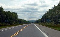
| Route 185 south of Rivière-du-Loup | ||||||||||||||||||||||
|
Course of the road
|
||||||||||||||||||||||
The Route 185 in the eastern Canadian province of Quebec is part of the Trans-Canada Highway system's. It runs between the sections of Autoroute 85 and has a length of 41 km.
Route description
The western section of Autoroute 85 ends at Saint-Antonin . It will be continued as a two-lane country road to the east. It only leads through the towns of Cabano and Notre-Dame-du-Lac , two districts of Témiscouata-sur-le-Lac . At Saint-Louis-du-Ha! Ha! The route then ends and continues through the eastern section of Autoroute 85.
Expansion projects
Autoroute 85 is to be further extended and should replace Route 185 by 2025. This will create a continuous freeway from Arnprior near Ottawa , the Ontario Highway 417 to New Glasgow on the Nova Scotia Highway 104 .
Web links
Commons : Route 185 - collection of pictures, videos and audio files
Individual evidence
- ^ Autoroute Claude-Béchard (85) - Réaménagement de la route 185 en autoroute. (No longer available online.) Gouvernement du Québec, Ministère des Transports, de la Mobilité durable et de l'Électrification des transports, formerly in the original ; Retrieved June 6, 2018 (French). ( Page no longer available , search in web archives )

