Saskatchewan Highway 16
The Highway 16 the Canadian prairie province of Saskatchewan is part of the Trans-Canada Highway -Netzes. This part operates under the name Yellowhead Highway and leads through the provinces of British Columbia , Alberta and Saskatchewan to Manitoba . The route is numbered 16 in all four provinces . The part in Saskatchewan has a length of 690 km and is part of the Canadian National Highway System as a so-called core route .
Route
The route begins on the Alberta border in the city of Lloydminster , which is part of both Alberta and Saskatchewan , on Alberta and Saskatchewan Highway 17 . It leads east and comes about 50 km west of Battleford into the valley of the North Saskatchewan River . This is followed by the highway, only to cross it at Battleford. At Langham the river is crossed a second time, but the river is also left. The highway continues in a south-easterly direction and comes to the largest city in the province, Saskatoon . As a bypass in the north and east, it leads around the city and meets several highways that open up the area around Saskatoon. The South Saskatchewan River is also crossed in Saskatoon . East of Saskatoon, Highway 16 takes you to the Quill Lakes , Canada's largest salt lakes. The route then runs in a south-easterly direction, bypassing the city of Yorkton in the northeast. Past Langenburg , the highway then meets the provincial border with Manitoba and continues there as Manitoba Highway 16 .
Signage
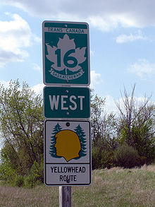
As part of the Trans-Canada Highway, the highway is marked with the special Trans-Canada sign. In addition, the Yellowhead Highway will be marked with a special sign along its entire route. The yellowhead symbol is reminiscent of Tête Jaune (French for yellow head). Tête Jaune was a trapper of Iroquois descent who led an expedition for the Hudson's Bay Company along this route to western Canada.
Web links
Individual evidence
- ^ National Highway System - An Overview. (PDF; 146.21 kB) Council of Ministers - Responsible for Transportation and Highway Safety, April 2008, accessed on June 29, 2016 (English).
- ^ The Annotated Ramsar List: Canada. In: The Annotated Ramsar List of Wetlands of International Importance. Ramsar Convention Bureau January 10, 2000, archived from the original December 30, 2007 ; accessed on July 21, 2012 (English).


