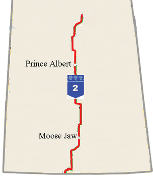
Saskatchewan Highway 2
The Saskatchewan Highway 2 is a highway in the Canadian prairie province of Saskatchewan . It runs in north-south direction and has a length of 798 km. Part of the highway between Moose Jaw and Prince Albert is called the Veterans Memorial Highway. The highway is partly part of the National Highway System and the CanAm Highway network.
Route
The highway begins on the border with the United States at the West Poplar River border station, south of which the route continues as Montana State Route 24 . It runs north-east to Fife Lake , from there it goes north to the small town of Assiniboine , where it meets Highway 13 , which crosses the province in an east-west direction. Further north, in front of the town of Moose Jaw, lies an air base for the Canadian armed forces , the Moose Jaw Air Vice Marshall CM McEwen Airport . This is where the Snowbirds are based, a well-known aerobatic team of the Canadian Airforce. North of Moose Jaw, the highway meets the Trans-Canada Highway ( Highway 1 ).
To the north of this, the route meets Buffalo Pound Lake , which is crossed with a dam . Highway 11 , which connects the provincial capital Regina with Saskatoon , runs further north . East of Saskatoon, Highway 2 crosses Highway 16 , the Yellowhead Highway , which heads east towards Winnipeg . South of Prince Albert , Highway 11, coming from the south, joins Highway 2. The North Saskatchewan River is crossed in Prince Albert and the route leads from there to the northern part of the province, which is only very sparsely populated. The route ends in La Ronge on Lac la Ronge and continues as Highway 102 .
The stretch between Prince Albert and La Ronge is the northernmost portion of the CanAm Highway, which begins in southern Texas . The section north of Moose Jaw to the junction of Highway 11 and the section from the confluence with Highway 11 south of Prince Albert to Prince Albert belong as a core route to the National Highway System (NHS), in addition, the section north of Prince Albert is called Northern Route guided in the NHS.
Individual evidence
- ^ Government of Saskatchewan: Highway 2 Designated "Veterans Memorial Highway" . Archived from the original on June 10, 2011. Retrieved June 18, 2018.
- ↑ Canada's National Highway System - Annual Report 2016. (PDF, 1.4 MB) Council of Ministers Responsible for Transportation and Highway Safety, September 2017, p. 31 , accessed on June 18, 2018 (English).
- ^ Julian Macdonald: Provincial Highways @ Saskatchewan Highways website . 1999-2003. Archived from the original on February 15, 2008. Retrieved June 18, 2018.
- ↑ WEST POPLAR RIVER. Canada Border Service Agency, accessed June 18, 2018 .
Web links
- Route description at milebymile.com (southern section)
- Route description at milebymile.com (section Prince Albert to La Ronge)


