Saskatchewan Highway 11
| Highway 11 in Saskatchewan, Canada | ||||||||||||||||||||||||||||||||||||||||||||||||||||||||||||||||||||||||||||||||||||||||||||||||||||||||||||||||||||||||||||||||||
| Louis Riel Trail | ||||||||||||||||||||||||||||||||||||||||||||||||||||||||||||||||||||||||||||||||||||||||||||||||||||||||||||||||||||||||||||||||||

|
||||||||||||||||||||||||||||||||||||||||||||||||||||||||||||||||||||||||||||||||||||||||||||||||||||||||||||||||||||||||||||||||||
| map | ||||||||||||||||||||||||||||||||||||||||||||||||||||||||||||||||||||||||||||||||||||||||||||||||||||||||||||||||||||||||||||||||||
| Basic data | ||||||||||||||||||||||||||||||||||||||||||||||||||||||||||||||||||||||||||||||||||||||||||||||||||||||||||||||||||||||||||||||||||
| Operator: | Saskatchewan Ministry of Highways and Infrastructure |
|||||||||||||||||||||||||||||||||||||||||||||||||||||||||||||||||||||||||||||||||||||||||||||||||||||||||||||||||||||||||||||||||
| Start of the street: |
Regina ( 50 ° 27 ′ N , 104 ° 34 ′ W ) |
|||||||||||||||||||||||||||||||||||||||||||||||||||||||||||||||||||||||||||||||||||||||||||||||||||||||||||||||||||||||||||||||||
| End of street: | south of Prince Albert ( 53 ° 8 ′ N , 105 ° 46 ′ W ) |
|||||||||||||||||||||||||||||||||||||||||||||||||||||||||||||||||||||||||||||||||||||||||||||||||||||||||||||||||||||||||||||||||
| Overall length: | 392 km | |||||||||||||||||||||||||||||||||||||||||||||||||||||||||||||||||||||||||||||||||||||||||||||||||||||||||||||||||||||||||||||||||
|
Course of the road
|
||||||||||||||||||||||||||||||||||||||||||||||||||||||||||||||||||||||||||||||||||||||||||||||||||||||||||||||||||||||||||||||||||
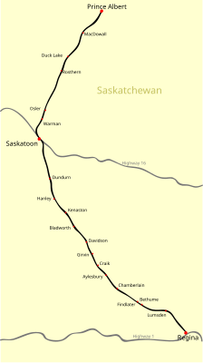
The Saskatchewan Highway 11 in the Central Canadian Prairie Province of Saskatchewan connects the two largest cities of Regina and Saskatoon . It has a length of 392 km and is a core route part of the National Highway System . The route is also known as the Louis Riel Trail and is named after a Métis leader .
course
The highway begins in the south of the province in its capital, Regina. It begins on the Trans-Canada Highway in the east of the city and leads from there through the grasslands around Regina to the northwest. At Lumsden , the route crosses the Qu'Appelle River . To the north of this on the Arm River is an archaeologically interesting area where the resident Métis hunted bison .
The route then meets Highway 2 for the first time , which leads directly to Prince Albert in the north and Moose Jaw in the south. The route continues in a north-westerly direction, north of Dundurn there is a training area for the Canadian armed forces . Further north is Saskatoon , the largest city in the province. Highway 11 meets Highway 16 , the Yellowhead Highway . A special feature follows: Highway 11 and 16 together form a ring around the city, i.e. H. the entire bypass will be marked with both highways. To the north of the city, Highway 11 leaves the ring road and runs parallel to the South Saskatchewan River . South of Prince Albert , it meets Highway 2 again and ends there.
expansion
A bypass is being built around Regina. A new node is being built east of the current start of Highway 11, from which Highway 11 will branch off in a south-westerly direction. Highway 11 is then led south or west of the city around Regina, only to join the old route in the north. It is planned to complete this construction project by the end of October 2019.
Web links
- milebymile.com route description , southern section (English)
- milebymile.com route description , northern section (English)
Individual evidence
- ↑ Canada's National Highway System - Annual Report 2017. (PDF) Council of Ministers Responsible for Transportation and Highway Safety, accessed on March 25, 2019 .
- ^ Louis Riel Trail - Hwy 11 - Regina to Saskatoon. Tourism Saskatchewan, accessed March 26, 2019 .
- ↑ Three Rivers Trail Newsletter. (PDF; 249 kB) Three Rivers Trail Association, October 13, 2004, p. 2 , archived from the original on February 24, 2009 ; accessed on March 26, 2019 (English).
- ↑ Plan for 2019-20. (PDF; 11.3 MB) Ministries of Highways and Infrastrucure, p. 10 , accessed on March 26, 2019 (English).

