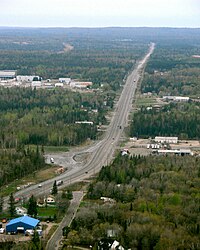
Ontario Highway 11
The Highway 11 is a 1789 km long road in Canadian province of Ontario. Highway 11 begins as a continuation of Minnesota State Highway 72 between Ontario and the US state of Minnesota , crossing the Rainy River at the village of Rainy River . It ends on Ontario Highway 400 at Barrie , where it joins. Highway 11 is in sections a part of the Trans-Canada Highway .
Route
The western beginning of the highway is in Rainy River. It forms the continuation of Minnesota State Highway 72 and leads in an easterly direction. Approx. 50 km after the start of the route, when coming from the north, Ontario Highway 17 meets Highway 11. From here, it is labeled as part of the Trans-Canada Highway . In a common route both run for the next 40 km to Fort Frances , Highway 17 branches off to the south and ends after a few meters at the border with the United States on the Fort Frances-International Falls International Bridge . Highway 11 follows the shore of Rainy Lake , then crosses the lake at a narrow point about 5 km north of the city. The lake is crossed over a distance of almost 4 km with the help of some smaller islands. The highway continues eastwards and reaches a sparsely populated area.
Highway 11 meets Highway 17 for the first time 280 km east of Fort Frances . Together the highways run for the next 160 km. The route passes through Thunder Bay and follows the shores of Lake Superior . Behind Nipigon the two highways separate. Highway 17 goes east to the city of Sudbury , while Highway 11 goes first north, then east. It opens up the parish Greenstone , which consists of the boroughs Beardmore, Geraldton and Longlac. In Cochrane , the route swings south. Near Porquis Junction, a community east of the Highway 45 km south of Cochrane, Highway 65 branches off to the northeast. The approximately 11 km long highway leads to Iroquois Falls . Highway 11 continues south-east and meets Highway 101 , with which it runs together for 6 km at Black River-Matheson . In New Liskeard , a suburb of Temiskaming Shores , Highway 65 crosses , which leads to the nearby province of Québec .
The route continues south and meets Highway 17 again before the city limits of North Bay , with which the following 4 km run together. Shortly after the freeway expansion began, the two routes separate again, with Highway 17 heading east into Greater Ottawa, while Highway 11 continues south. The following 175 km are developed as a freeway and mostly lead as bypasses around the connected communities. In 2012, the bypass around Sundridge was opened to traffic, the old route is now continued as Highway 124 . The expansion ends south of Gravenhurst . At Orillia another 9 km stretch has been developed as a freeway, where the route also meets Highway 12 , which leads west to Midland and east to Whitby . From here the distinction as a Trans-Canada Highway ends. The following 22 km are not yet developed as a freeway. The freeway begins again at Barrie , but that ends Highway 11 and continues as Highway 400A until it joins Highway 400 .
expansion
The section between Thunder Bay and Nipigon, on which Highway 11 and 17 run together, is to be expanded to four lanes in the coming years. The expansion will take place in sections and should not be completed before 2019.
Individual evidence
- ↑ Highway 11 four-laning rolls along. (No longer available online.) North Bay Nugget, formerly the original ; Retrieved December 17, 2012 . ( Page no longer available , search in web archives ) Info: The link was automatically marked as defective. Please check the link according to the instructions and then remove this notice.
- ↑ Northern Highways Program 2015-2019. (pdf, 989 KB) Ministry of Northern Development and Mines Ontario, August 19, 2015, accessed on April 12, 2016 .


