Renfrew (Ontario)
| Renfrew | ||
|---|---|---|
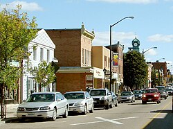
 Street in Renfrew |
||
| Location in Ontario | ||
|
|
||
| State : |
|
|
| Province : | Ontario | |
| County : | Renfrew County | |
| Coordinates : | 45 ° 29 ′ N , 76 ° 42 ′ W | |
| Area : | 12.77 km² | |
| Residents : | 7846 (status: 2006) | |
| Population density : | 614.4 inhabitants / km² | |
| Time zone : | Eastern Time ( UTC − 5 ) | |
| Postal code : | K7V | |
| Mayor : | Sandra J. Heins | |
| Website : | town.renfrew.on.ca | |
Renfrew [ ˈɹɛnfɹu ] is a small town in the province of Ontario ( Canada ) and is located about 80 km west of Ottawa .
The place is located in the forests of Ontario near the border with Québec and consists mainly of single-family houses and a few churches in the modern style. The main street of the village is characterized by shops, restaurants and banks. Renfrew is the third largest city in the county of the same name after Petawawa and Pembroke. Renfrew is a traffic junction between Highway 132 and 60, which then joins the Trans Canada Highway. The town is also known for its historical importance when the National Hockey League was founded.
Personalities
- John Ambrose O'Brien (1885–1968), co-founder of the National Hockey Association
- Alex Phillips (1900–1977), actor and cameraman
- Ted Lindsay (1925–2019), ice hockey player, coach and official
- Jim Peplinski (* 1960), ice hockey player
- Anthony Iob (* 1971), Italian-Canadian ice hockey player
- Alan Letang (* 1975), Canadian-Croatian ice hockey player
Web links
Commons : Renfrew - collection of pictures, videos and audio files
- Website of the community (English)
