Parry Sound District
| Parry Sound District | |
|---|---|
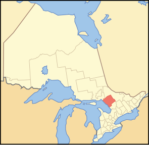
 Location of the region in Ontario
|
|
| Basic data | |
| Country | Canada |
| province |
Ontario
|
| Administrative headquarters | Parry Sound |
| Coordinates : | 45 ° 43 ′ N , 79 ° 48 ′ W |
| Residents | 42,162 (as of 2011) |
| surface | 9,322.80 km² |
| Population density | 4.5 inhabitants / km² |
| Time zone : | Eastern Standard Time ( UTC −5) Eastern Daylight Time ( UTC −4, daylight saving time) |
The Parry Sound District is an administrative district in the center of the Canadian province of Ontario . The main town is Parry Sound . The population is 42,162 (2011), the area 9322.80 km², which corresponds to a population density of 4.5 inhabitants per km². The district lies on the east bank of the George Bay of Lake Huron and includes a large part of the Algonquin Provincial Park .
structure
Municipalities:
Reserves:
- Dokis 9
- French River 13
- Henvey Inlet 2
- Magnetawan 1
- Naiscoutaing 17A
- Parry Island First Nation
- Shawanaga 17
Unregulated areas:
- Parry Sound, Unorganized, Center Part
- Parry Sound, Unorganized, North East Part
Web links
Commons : Parry Sound District, Ontario - Collection of pictures, videos, and audio files