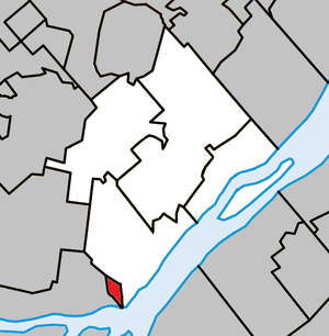
Charlemagne (Quebec)
| Charlemagne | ||
|---|---|---|
| Location in Quebec | ||
|
|
||
| State : |
|
|
| Province : | Quebec | |
| Administrative region : | Lanaudière | |
| MRC or equivalent : | L'Assomption | |
| Coordinates : | 45 ° 43 ′ N , 73 ° 29 ′ W | |
| Height : | 5 m | |
| Area : | 2.16 km² | |
| Residents : | 5853 (as of 2011) | |
| Population density : | 2,709.7 inh. / Km² | |
| Time zone : | Eastern Time ( UTC − 5 ) | |
| Municipality number: | 60005 | |
| Postal code : | J5Z | |
| Area code : | +1 450 | |
| Mayor : | Normand Grenier | |
| Website : | www.ville.charlemagne.qc.ca | |
 Located in the MRC L'Assomption |
||
Charlemagne ( ʃaʁ.lə.maɲ ) is a city in the southwest of the Canadian province of Québec . It is located in the Lanaudière region , around 20 km north of central Montreal . Charlemagne belongs to the regional county municipality (municipalité régionale du comté) L'Assomption , has an area of 2.16 km² and has 5,853 inhabitants (2011).
geography
Charlemagne is located in the Rive-Nord region , between the northern bank of the Rivière des Prairies and the western bank of the Rivière L'Assomption . The latter flows into the Rivière des Prairies at the level of the Île Bourdon, which in turn flows into the Saint Lawrence River a kilometer further east . On the opposite side of the Île Bourdon is the Île de Montréal . The terrain is largely flat. Neighboring communities are Repentigny in the north, Varennes in the east (on the opposite bank of the St. Lawrence River), Montreal in the south and Terrebonne in the west.
history
Today's urban area was uninhabited well into the 19th century and belonged to the municipality of Le Gardeur ( merged with Repentigny in 2002 ). In 1867, the L'Assomption Lumber Company opened a sawmill near the mouth of the Rivière L'Assomption. A settlement was built around it that was named Charlemagne, named after Charlemagne . The rapidly growing village was declared an independent municipality in 1906 and received city status in 1969. Charlemagne is a member of the Communauté métropolitaine de Montréal association founded in 2000 .
population
According to the 2011 census, Charlemagne had 5,853 inhabitants, which corresponds to a population density of 2709.7 inh / km². 94.6% of the population stated French as their main language, the share of English was 1.5%. 0.4% said they were bilingual (French and English), other languages and multiple answers made up 3.5%. Only French spoke 65.0%. In 2001, 94.7% of the population were Roman Catholic , 1.6% Protestant and 3.4% non-denominational.
traffic
The main artery of Repentigny is Route 640, which merges into Autoroute 640 on the western outskirts . This freeway intersects with Autoroute 40 , the main road link between the cities of Montreal and Québec . A Canadian National Railway runs north-south , but there is no train station in the city. Several CRT Lanaudière bus routes connect Charlemagne with Montreal and the neighboring communities.
Personalities
Among other things, the singer Celine Dion was born in Charlemagne . Even Camille Laurin comes from Charlemagne.
Web links
- Official website of Charlemagne (French)
Individual evidence
- ↑ Charlemagne. Commission de toponymie du Québec, accessed December 27, 2013 (French).
- ↑ Population profile of the municipality of Charlemagne. In: 2011 Census. Statistics Canada , 2011, accessed December 27, 2013 (French).
- ↑ Population profile of the municipality of Charlemagne. In: 2001 Census. Statistics Canada , 2001, accessed December 27, 2013 (French).

