
Terrebonne (Québec)
| Terrebonne | |||
|---|---|---|---|
 Saint-Louis-de-France church with mill |
|||
 coat of arms |
|||
| Location in Quebec | |||
|
|||
| State : |
|
||
| Province : | Quebec | ||
| Administrative region : | Lanaudière | ||
| MRC or equivalent : | Les Moulins | ||
| Coordinates : | 45 ° 42 ′ N , 73 ° 39 ′ W | ||
| Height : | 15 m | ||
| Area : | 154.74 km² | ||
| Residents : | 106,322 (as of 2011) | ||
| Population density : | 687.1 inhabitants / km² | ||
| Time zone : | Eastern Time ( UTC − 5 ) | ||
| Municipality number: | 64008 | ||
| Postal code : | J6W | ||
| Area code : | +1 450 | ||
| Mayor : | Jean-Marc Robitaille | ||
| Website : | www.ville.terrebonne.qc.ca | ||
 Located in the MRC Les Moulins |
|||

Terrebonne is a city in the southwest of the Canadian province of Quebec . It is located in the administrative region of Lanaudière , around 20 km north of downtown Montreal . Terrebonne is the administrative seat of the regional county municipality (municipalité régionale du comté) Les Moulins , has an area of 154.74 km² and has 106,322 inhabitants (2011). The present city was created in 2001 through the merger of three municipalities.
geography
Terrebonne lies along the north bank of the Rivière des Mille Îles , an estuary of the Ottawa . The city consists of three clearly separated settlements. In the middle of the elongated urban area, near the mouth of the Rivière Mascouche , is the main settlement of Terrebonne. Almost 15 km northwest of it is La Plaine, about 10 km east of Lachenaie (opposite the mouth of the Rivière des Prairies ). There are several islands in the Rivière des Mille Îles, including Île Saint-Jean, Île aux Vaches, Île Saint-Pierre and Île des Moulins; with the exception of Île Saint-Jean, they are largely uninhabited. The terrain is largely flat and partly wooded.
Neighboring municipalities are Saint-Lin-Laurentides and Saint-Roch-de-l'Achigan in the north, Mascouche in the northeast, Repentigny and Charlemagne in the east, Montreal in the southwest, Laval in the south, Bois-des-Filion and Lorraine in the southwest, and Blainville Sainte-Anne-des-Plaines in the west and Sainte-Sophie in the northwest.
history
André Daulier-Deslandes, General Secretary of the French West India Company , was awarded the Seigneurie Terrebonne in 1673 . The name means "good earth" and indicates the fertility of the soil. After the Seigneurie was sold to Louis Lecompte Dupré in 1681, the settlement began gradually. The first mill on the Île des Moulins started operating in 1710, and the first church followed in 1731. Joseph Masson , who is considered to be the first French Canadian millionaire, acquired the Seigneurie in 1832 and promoted its economic development, to which the construction of the first bridge in 1834 contributed in particular. One year after the abolition of the manor in 1855, the municipality of Terrebonne was founded, which received city status in 1860. In 1922 a major fire destroyed part of the city center. From the 1950s onwards, Terrebonne developed into an important suburb of Montreal.
Charles Aubert de La Chesnaye, the richest merchant in New France , acquired part of the Seigneurie Repentigny in 1670 . Two years later the Lachenaie settlement named after him was built. The place name is also a reference to the numerous oak groves (French chênaies ). The parish was founded in 1683. During the Beaver Wars , the place was one of the most fiercely contested and, when the peace treaty was signed in 1701, had fewer than half of the original inhabitants. The place gained some importance from 1731 as the starting point of the Chemin du Roy . A year after the abolition of manorial power, the municipality of Saint-Charles-de-Lachenaie was founded in 1855. This received city status in 1972 and was renamed Lachenaie.
The La Plaine settlement was built around 1840 at the intersection of two country roads. Due to the continued growth of the settlement, its inhabitants demanded the establishment of an independent municipality in 1912. This took place ten years later through the cession of territory by the municipalities of Saint-Lin, Mascouche and Sainte-Anne-des-Plaines. The new municipality was named Saint-Joachim-de-La Plaine, in 1969 it was renamed La Plaine.
On January 1, 2001, Lachenaie (then 20,000 inhabitants) and La Plaine (17,000) merged with Terrebonne (46,000). The city is a member of the communauté métropolitaine de Montréal .
population
According to the 2011 census, Terrebonne had 106,322 inhabitants, which corresponds to a population density of 687.1 inh / km². 90.5% of the population stated French as their main language, the share of English was 2.1%. 0.6% said they were bilingual (French and English), other languages and multiple answers accounted for 6.8%. Only French spoke 59.4%. In 2001, 93.5% of the population were Roman Catholic , 1.9% Protestant and 3.9% of no religion.
traffic
Two important traffic axes through Terrebonne are the Autoroute 25 and the Route 125 . Both connect Montreal with the northern Laurentine Mountains . Autoroute 640 crosses on the northern outskirts of Terrebonne . This motorway connects the cities on the Rivière de Mille Îles and joins Autoroute 40 east of Lachenaie . The Laval - Trois-Rivières railway line runs through Terrebonne, but only transports goods. In 2014, an AMT suburban line from Montreal to Mascouche is to go into operation, with a train station in Lachenaie. Several CRT Lanaudière bus routes connect Terrebonne with the surrounding communities as well as Laval and Montreal.
Twin town
There has been a town partnership with Vitré in France since 1983 .
Personalities
- Marie Anne Blondin (1809–1890), beatified founder of the Congregation of the Sisters of Saint Anne
- Alphonse Desjardins (1841–1912), politician and entrepreneur
- Thomas Nicholson Gibbs (1821-1883), politician
- Louis-François-Rodrigue Masson (1833–1903), politician
- Palmièri (1871–1950), actor
- Louis-Olivier Taillon (1840–1923), politician
photos

Depiction from 1810

New mill

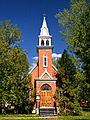
Saint-Louis-de-France church
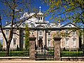
Collège Saint-Sacrement
Former Anglican Church of St. Michael


Web links
- Terrebonne Official Website (French)
Individual evidence
- ↑ a b c Terrebonne. Commission de toponymie du Québec, accessed January 14, 2014 (French).
- ^ Terrebonne, une histoire de vision. (No longer available online.) City of Terrebonne, May 17, 2013, archived from the original on January 16, 2014 ; Retrieved January 14, 2014 (French). Info: The archive link was inserted automatically and has not yet been checked. Please check the original and archive link according to the instructions and then remove this notice.
- ↑ Lachenaie, une histoire de courage. (No longer available online.) City of Terrebonne, May 17, 2013, archived from the original on January 16, 2014 ; Retrieved January 14, 2014 (French). Info: The archive link was inserted automatically and has not yet been checked. Please check the original and archive link according to the instructions and then remove this notice.
- ↑ La Plaine, une histoireacoustace. (No longer available online.) City of Terrebonne, May 17, 2013, archived from the original on January 16, 2014 ; Retrieved January 14, 2014 (French). Info: The archive link was inserted automatically and has not yet been checked. Please check the original and archive link according to the instructions and then remove this notice.
- ↑ Population profile of the municipality of Terrebonne. In: 2011 Census. Statistics Canada , 2011, accessed January 14, 2014 (French).
- ↑ Population profile of the municipality of Terrebonne. In: 2001 Census. Statistics Canada , 2001, accessed January 14, 2014 (French).