Ponta do Pico
| Ponta do Pico | ||
|---|---|---|
|
The Pico from the neighboring island of Faial seen from |
||
| height | 2351 m | |
| location | Pico Island , Azores , Portugal | |
| Mountains | Mid-Atlantic Ridge | |
| Coordinates | 38 ° 28 '6 " N , 28 ° 23' 56" W | |
|
|
||
| Type | Stratovolcano | |
| rock | basalt | |
| Last eruption | 1720 | |
| particularities | highest mountain in Portugal and the mid-Atlantic ridge | |
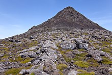
Ponta do Pico (Portuguese also called Montanha do Pico , Serra do Pico , Pico Alto or simply Pico ) is a stratovolcano on the Azores island of the same name, Pico . With a height of 2351 m , it is the highest mountain in Portugal and the Mid-Atlantic Ridge and one of the highest volcanoes in any European country .
At the top there is a volcanic crater 500 m in diameter and 30 meters deep and in it the Piquinho ( Pico Pequeno ), a small volcanic cone that rises 70 m and forms the actual summit.
Web links
Commons : Ponta do Pico - collection of images, videos and audio files
- Ponta do Pico in the Global Volcanism Program of the Smithsonian Institution (English)
- Photographic chronicle of a climb to the top of the Pico volcano.
- Current photos from the ascent to Mount Pico on the island of the same name in the Azores


