Monte Baranta
Monte Baranta was only discovered in 1962 and excavated in 1979. It is a proto-Nuragic cult complex, which is mainly associated with the Monte Claro culture (2700–2200 BC). It is located on the edge of a high plateau southeast of Olmedo in the province of Sassari in Sardinia .
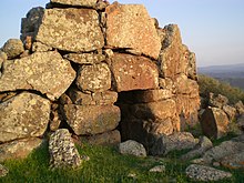
Monte Baranta is laid out similar to a section fortification. Its approximately 100 m long, relatively straight barrier wall, running from north to south, with a narrow passage in the north, seals off the accessible side of a spur . The maximum three meters high and four meters wide wall consists of a mixture of large and small stones. Some of them are clearly reused standing stones . In front of and behind this wall were the remains of structural structures. The area in front of the wall consists of the remains of an approximately ten meter high round structure, which also contains broken menhirs and a fallen menhir, while behind the wall are the remains of seven more or less rectangular buildings. They only contained ceramic finds from the Monte Claro culture, so they were no longer used later.
The horseshoe-shaped structure known as the "round tower" stands on the edge of a lower terrace in front of the spur. This better-preserved building has two narrow 2.1 m high entrances to the north and west and a total area of 390 m², with a maximum width of 20.6 m. The width of the irregular wall, consisting of huge boulders made of trachyte , varies between 6.5 m and 4.15 m with a current remaining height of around 3.5 m. It encloses a presumably always open interior. Its flat floor consists of plates. In the southwest there is a rudimentary staircase in the masonry. It led to the wide wall of the bastion. During the excavations, large amounts of pottery and tools of the Monte Claro culture and later cultures were found.
Apparently the upper level was built exclusively by the supporters of the Monte Claro culture, used for a relatively short time and then hastily abandoned. After a few centuries, around 2000 BC BC, the supporters of the Bonnanaro culture also only used the tower for a short period of time. Thereafter, the place was sporadically visited by nuragic bearers and the Romans .
Nearby is the Masala nuraghe .
See also
literature
- Alberto Moravetti: Il complesso prenuragico di Monte Baranta . Delfino, Sassari 2000, ISBN 88-7138-190-4 , ( Sardegna archeologica, Guide e itinerari 28).
Web links
Coordinates: 40 ° 37 ′ 55 " N , 8 ° 23 ′ 47.9" E

