
Montezuma (Costa Rica)
| Montezuma | ||
|---|---|---|
|
Coordinates: 9 ° 39 ′ N , 85 ° 4 ′ W Montezuma on the map of Puntarenas province
|
||
| Basic data | ||
| Country | Costa Rica | |
| province | Province of Puntarenas | |
| Residents | 500 | |
| Detailed data | ||
| Time zone | UTC −6 | |

Montezuma is a village on the coast of the Pacific Ocean in the province of Puntarenas in the Central American state of Costa Rica . The village is known for its yoga classes and modern Rastafarians. Locals therefore affectionately call it Montefuma . Due to its nature, several volunteer programs are offered in and around the village. Participants can dedicate themselves to protecting turtles or cleaning up beaches and rainforests of litter.
geography
Located on the southern tip of the Nicoya Peninsula , the village stretches for several kilometers along a rugged coastline, whose small rocky headlands separate the bays and sandy beaches. Playa Grande, popular with surfers, extends about 7 kilometers north of the village . Near the village and surrounded by jungle are the Montezuma waterfalls, which are home to natural swimming pools. About 9 kilometers south of Montezuma is Costa Rica's oldest nature reserve, Cabo Blanco .
history
Originally the village was characterized by fishing. Today it is a popular destination for backpackers and ecotourists .
gallery

Playa Grande, 7 kilometers north of Montezuma
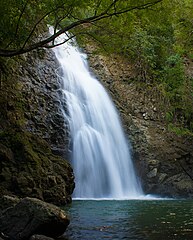
Waterfall near Montezuma

Beach in Montezuma


Individual evidence
- ↑ a b c Lonely Planet: Costa Rica . Stuttgart February 2015, 5th German edition, pages 356–358, ISBN 978-3-8297-2355-8 .
- ↑ http://nicoyapeninsula.com/montezuma/ Montezuma. NicoyaPeninsula.com. Retrieved April 10, 2016.