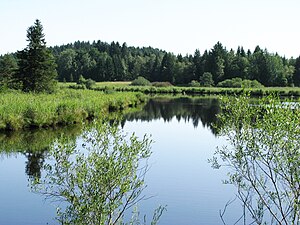
Mooshamer pond
| Mooshamer pond | ||
|---|---|---|

|
||
| View over the Mooshamer Weiher to the northeast | ||
| Geographical location | Bavaria | |
| Tributaries | Mooshamer Weiherbach | |
| Drain | Mooshamer Weiherbach → Moosbach → Isar → Danube → Black Sea | |
| Location close to the shore | Moosham | |
| Data | ||
| Coordinates | 47 ° 54 '23 " N , 11 ° 31' 28" E | |
|
|
||
| Altitude above sea level | 635 m above sea level NN | |
| surface | 2.4 ha | |
| length | 350 m | |
| width | 100 m | |
The Mooshamer Weiher is an artificial lake west of Moosham in the municipality of Egling in the Bad Tölz-Wolfratshausen district . It is dammed on the south side. The lake eventually drains into the Isar via the Mooshamer Weiherbach .
The lake is located in the Mooshamer Weiher nature reserve . In the nearby Spatenbräufilz , which also belongs to this landscape protection area, peat used to be cut, for this it was largely drained. This raised bog has been renatured since 1995. The old drainage ditches were closed, which made the area permanently moist again, and the spruce, Scots pine and birch trees, which are not typical for high moorland, were removed.
The lake is used for fish farming.
Individual evidence
- ↑ a b c d BayernAtlas of the Bavarian State Government ( notes )
- ↑ Saving the spade felts
- ↑ Mooshammer Weiher - www.fischereiverein-muenchen.de
Web links
Commons : Mooshamer Weiher - Collection of images, videos and audio files
