
Mooshamer Weiherbach
|
Mooshamer Weiherbach Ascholdinger Bach |
||
 Mooshamer Weiherbach at the Mooshamer Weiher |
||
| Data | ||
| location | Upper Bavaria | |
| River system | Danube | |
| Drain over | Moosbach → Isar → Danube → Black Sea | |
| source | south of Thanning 47 ° 54 ′ 48 ″ N , 11 ° 32 ′ 21 ″ E |
|
| Source height | 650 m | |
| muzzle |
Moosbach (Isar) Coordinates: 47 ° 53 ′ 31 ″ N , 11 ° 29 ′ 26 ″ E 47 ° 53 ′ 31 ″ N , 11 ° 29 ′ 26 ″ E |
|
| Mouth height | approx. 590 m | |
| Height difference | approx. 60 m | |
| Bottom slope | approx. 9.1 ‰ | |
| length | approx. 6.6 km | |
| Left tributaries | Weiherbach | |
The Mooshamer Weiherbach or Ascholdinger Bach is a left tributary of the Moosbach in Upper Bavaria .
The Mooshamer Weiherbach arises south of Thanning , first flows through a few smaller ponds and then runs in a largely south-westerly direction. It flows through the nature reserve Mooshamer Weiher at Spatenbräufilz and the Siegertshofer Weiher . Before Ascholding the brook makes a bend to the west, runs through the village itself and finally flows into the Moosbach .
gallery

Spatenbräumz
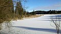
Mooshamer Weiher in winter

.jpg)
Web links
Commons : Mooshamer Weiherbach - Collection of images, videos and audio files