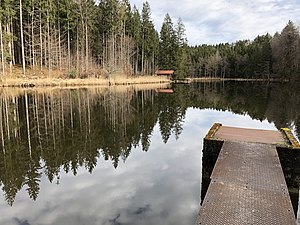
Siegertshofer Weiher
| Siegertshofer Weiher | ||
|---|---|---|

|
||
| Siegertshofer Weiher | ||
| Geographical location | Bavaria | |
| Tributaries | Mooshamer Weiherbach | |
| Drain | Mooshamer Weiherbach → Moosbach → Isar → Danube → Black Sea | |
| Location close to the shore | Siegertshofen | |
| Data | ||
| Coordinates | 47 ° 53 '30.5 " N , 11 ° 31' 14.2" E | |
|
|
||
| Altitude above sea level | 618 m above sea level NHN | |
| surface | 1 ha | |
The Siegertshofer Weiher is an artificial lake near the hamlet of Siegertshofen in the municipality of Egling in the Bavarian district of Bad Tölz-Wolfratshausen .
description
The approximately 1.0 hectare lake is located at about 618 m above sea level. NHN less than half a kilometer northwest of the outskirts of Siegertshofen in the beginning of the forest and is traversed by the Mooshamer Weiherbach from northeast to southwest . A historical map from the 19th century shows no water at the current location of the pond.
Individual evidence
Web links
Commons : Siegertshofer Weiher - Collection of images, videos and audio files
