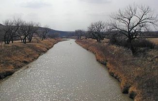
Moreau River
| Moreau River | ||
|
Location of the Moreau River (colored turquoise) |
||
| Data | ||
| Water code | US : 1265832 | |
| location | South Dakota (USA) | |
| River system | Mississippi River | |
| Drain over | Missouri River → Mississippi River → Gulf of Mexico | |
| source | in Harding County 45 ° 8 ′ 42 ″ N , 102 ° 49 ′ 51 ″ W. |
|
| muzzle | in the Missouri River dammed up to Lake Oahe coordinates: 45 ° 21 ′ 19 ″ N , 100 ° 22 ′ 31 ″ W 45 ° 21 ′ 19 ″ N , 100 ° 22 ′ 31 ″ W
|
|
| length | 320 km | |
| Communities | Usta , Iron Lightning , Thunder Butte , Green Grass , Whitehorse | |
|
Moreau River near Whitehorse |
||
The Moreau River is a right tributary of the Missouri River and is approximately 200 miles long. It flows in the US state of South Dakota .
The Santee-Dakota of the Cheyenne River Sioux Tribe called the Hinhan Wakpa - 'Owl River'. The river rises in two creeks in the Badlands of Harding County . The source of the southern arm is about 20 miles west of the source of the northern arm, which rises near Crow Buttes . The two arms run in the ESE direction and converge in south Perkins County . The Moreau River flows through the Cheyenne River Indian Reservation , past the towns of Usta , Iron Lightning , Thunder Butte , Green Grass and Whitehorse . It flows into the Missouri in Lake Oahe .

